
Bellingham topographic map
Click on the map to display elevation.
Bellingham
Bellingham is characterized by a diverse and striking topography that combines coastal and mountainous landscapes. The city lies along the eastern shore of Bellingham Bay, where the waters of the Puget Sound meet the foothills of the Cascade Range. Rising abruptly from the shoreline, the surrounding hills and mountains create a dramatic backdrop, with elevations reaching over 6,000 feet within a short distance from the bay. This unique geography results in a variety of ecosystems, including lush forests, rocky outcrops, and scenic waterfront areas. The area’s terrain offers residents and visitors alike easy access to numerous outdoor recreational opportunities, from hiking and mountain biking in the nearby Chuckanut Mountains to kayaking in the calm waters of the bay, making Bellingham a notable destination for nature enthusiasts.
About this map
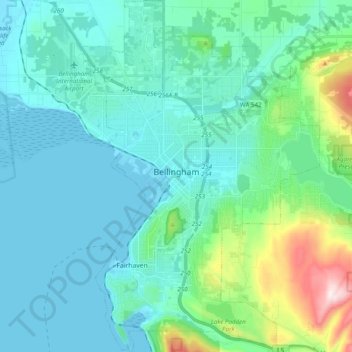
Name: Bellingham topographic map, elevation, terrain.
Location: Bellingham, Whatcom County, Washington, United States (48.68801 -122.53146 48.81741 -122.39871)
Average elevation: 292 ft
Minimum elevation: -20 ft
Maximum elevation: 1,772 ft
Whatcom County trails, hiking, mountain biking, running and outdoor activities
Other topographic maps
Click on a map to view its topography, its elevation and its terrain.
Tomyhoi Peak
United States > Washington > Whatcom County
The nearest higher peak is Canadian Border Peak, 2.4 miles (3.9 km) to the northeast. Precipitation runoff on the east side of Tomyhoi Peak drains into Tomyhoi Lake and Tomyhoi Creek, whereas the west side of the mountain drains into Damfino Creek, all eventually reaching the Chilliwack River in Canada.…
Average elevation: 5,184 ft
Mount Redoubt
United States > Washington > Whatcom County
The North Cascades features some of the most rugged topography in the Cascade Range with craggy peaks, spires, ridges, and deep glacial valleys. Geological events occurring many years ago created the diverse topography and drastic elevation changes over the Cascade Range leading to the various climate…
Average elevation: 6,791 ft
Ruby Mountain
United States > Washington > Whatcom County
Ruby Mountain is a prominent 7,412-foot (2,259-metre) mountain summit located in the North Cascades Range of Washington state. It is situated in Ross Lake National Recreation Area which is part of the North Cascades National Park Complex. The Diablo Lake Overlook along the North Cascades Highway is at the foot…
Average elevation: 5,679 ft
Bellingham
United States > Washington > Whatcom County > Bellingham
According to the United States Census Bureau, the city has a total area of 28.90 square miles (74.85 km2), of which, 27.08 square miles (70.14 km2) is land and 1.82 square miles (4.71 km2) is water. The lowest elevations are at sea level along the waterfront. Alabama Hill is one of the higher points in the…
Average elevation: 423 ft