
Hamilton topographic map
Interactive map
Click on the map to display elevation.
About this map
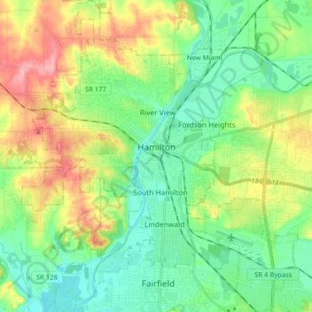
Name: Hamilton topographic map, elevation, terrain.
Location: Hamilton, Butler County, Ohio, 45013, United States (39.33450 -84.63024 39.45728 -84.49108)
Average elevation: 689 ft
Minimum elevation: 535 ft
Maximum elevation: 994 ft
Other topographic maps
Click on a map to view its topography, its elevation and its terrain.
Oxford Township
United States > Ohio > Butler County
Oxford Township, Butler County, Ohio, 45056, United States
Average elevation: 948 ft
Okeana
United States > Ohio > Butler County
Okeana, Morgan Township, Butler County, Ohio, 45053, United States
Average elevation: 741 ft
Darrtown
United States > Ohio > Butler County
Darrtown, Milford Township, Butler County, Ohio, United States
Average elevation: 781 ft
Wieche Field
United States > Ohio > Butler County > Seven Mile
Wieche Field, Seven Mile, Wayne Township, Butler County, Ohio, United States
Average elevation: 682 ft
Woodsdale
United States > Ohio > Butler County
Woodsdale, Madison Township, Butler County, Ohio, 45055, United States
Average elevation: 669 ft
Wetherington
United States > Ohio > Butler County > Wetherington
Wetherington, West Chester Township, Butler County, Ohio, United States
Average elevation: 856 ft
Somerville
United States > Ohio > Butler County
Somerville, Milford Township, Butler County, Ohio, United States
Average elevation: 840 ft
Seven Mile
United States > Ohio > Butler County
Seven Mile, Wayne Township, Butler County, Ohio, 45062, United States
Average elevation: 686 ft
Jacksonburg
United States > Ohio > Butler County
Jacksonburg, Wayne Township, Butler County, Ohio, United States
Average elevation: 935 ft
Williamsdale
United States > Ohio > Butler County
Williamsdale, St. Clair Township, Butler County, Ohio, 45055, United States
Average elevation: 633 ft
Millville
United States > Ohio > Butler County
Millville, Ross Township, Butler County, Ohio, United States
Average elevation: 679 ft
College Corner
United States > Ohio > Butler County
College Corner, Oxford Township, Butler County, Ohio, United States
Average elevation: 997 ft
Lemon Township
United States > Ohio > Butler County
Lemon Township, Butler County, Ohio, United States
Average elevation: 699 ft
Trenton
United States > Ohio > Butler County
Trenton, Butler County, Ohio, 45067, United States
Average elevation: 656 ft
Madison Township
United States > Ohio > Butler County
Madison Township, Butler County, Ohio, United States
Average elevation: 751 ft
West Chester
United States > Ohio > Butler County > West Chester
West Chester, West Chester Township, Butler County, Ohio, 45069, United States
Average elevation: 758 ft
Liberty Township
United States > Ohio > Butler County
Liberty Township, Butler County, Ohio, United States
Average elevation: 764 ft
Morgan Township
United States > Ohio > Butler County
Morgan Township, Butler County, Ohio, United States
Average elevation: 778 ft
Bethany
United States > Ohio > Butler County
Bethany, Liberty Township, Butler County, Ohio, United States
Average elevation: 850 ft
Peffer Park
United States > Ohio > Butler County > Oxford
Peffer Park, Oxford, Oxford Township, Butler County, Ohio, United States
Average elevation: 869 ft
Ross Township
United States > Ohio > Butler County
Ross Township, Butler County, Ohio, 45061, United States
Average elevation: 692 ft
Macedonia
United States > Ohio > Butler County
Macedonia, Morgan Township, Butler County, Ohio, 45053, United States
Average elevation: 810 ft
Hanover Township
United States > Ohio > Butler County
Hanover Township, Butler County, Ohio, United States
Average elevation: 804 ft
Oxford
United States > Ohio > Butler County
Oxford, Oxford Township, Butler County, Ohio, 45056, United States
Average elevation: 915 ft
Fairfield Township
United States > Ohio > Butler County
Fairfield Township, Butler County, Ohio, 45011, United States
Average elevation: 679 ft
Beckett Ridge
United States > Ohio > Butler County > Beckett Ridge
Beckett Ridge, West Chester Township, Butler County, Ohio, United States
Average elevation: 692 ft
Wayne Township
United States > Ohio > Butler County
Wayne Township, Butler County, Ohio, 45062, United States
Average elevation: 856 ft
Astoria
United States > Ohio > Butler County
Astoria, Madison Township, Butler County, Ohio, United States
Average elevation: 863 ft
West Chester Township
United States > Ohio > Butler County
West Chester Township, Butler County, Ohio, 45069, United States
Average elevation: 755 ft
Ross
United States > Ohio > Butler County
Ross, Ross Township, Butler County, Ohio, 45061, United States
Average elevation: 607 ft
Olde West Chester
United States > Ohio > Butler County
Olde West Chester, West Chester Township, Butler County, Ohio, United States
Average elevation: 745 ft
Crawford Woods
United States > Ohio > Butler County > Hamilton
Crawford Woods, East Hamilton, Hamilton, Butler County, Ohio, United States
Average elevation: 673 ft
Middletown
United States > Ohio > Butler County
Middletown, Butler County, Ohio, United States
Average elevation: 709 ft
Reily
United States > Ohio > Butler County > Reily
Reily, Reily Township, Butler County, Ohio, United States
Average elevation: 837 ft
Fairfield
United States > Ohio > Butler County
Fairfield, Butler County, Ohio, United States
Average elevation: 699 ft
Monroe
United States > Ohio > Butler County
Monroe, Lemon Township, Butler County, Ohio, United States
Average elevation: 725 ft
Oneida
United States > Ohio > Butler County > Middletown
Oneida, Middletown, Butler County, Ohio, 45044, United States
Average elevation: 669 ft
New Miami
United States > Ohio > Butler County
New Miami, St. Clair Township, Butler County, Ohio, United States
Average elevation: 617 ft
Gano
United States > Ohio > Butler County
Gano, West Chester Township, Butler County, Ohio, 45241, United States
Average elevation: 692 ft