
Garibaldi topographic map
Click on the map to display elevation.
About this map
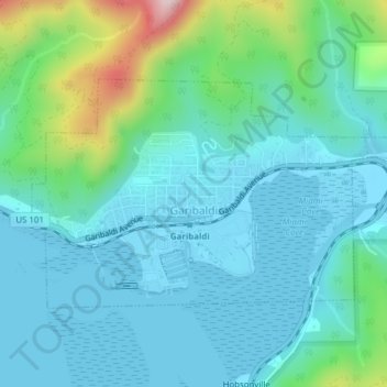
Name: Garibaldi topographic map, elevation, terrain.
Location: Garibaldi, Tillamook County, Oregon, 97118, United States (45.55297 -123.92735 45.56895 -123.89022)
Average elevation: 243 ft
Minimum elevation: -20 ft
Maximum elevation: 1,273 ft
Tillamook County trails, hiking, mountain biking, running and outdoor activities
Other topographic maps
Click on a map to view its topography, its elevation and its terrain.
Neahkahnie Mountain
United States > Oregon > Tillamook County
Neahkahnie Mountain is a mountain, or headland, on the Oregon Coast, north of Manzanita in Oswald West State Park overlooking U.S. Route 101, that has a pass elevation of approximately 620 feet (190 m), which is the third highest point of the highway in Oregon. The peak is part of the Northern Oregon Coast…
Average elevation: 538 ft
Seaview City Park
United States > Oregon > Tillamook County > Rockaway Beach
Average elevation: 105 ft