
Make a donation
Gear up for your next adventure:
As an Amazon Associate, this site earns from qualifying purchases at no extra cost to you.
Mount Hebo topographic map
Click on the map to display elevation.
Make a donation
Gear up for your next adventure:
As an Amazon Associate, this site earns from qualifying purchases at no extra cost to you.
About this map
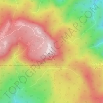
Name: Mount Hebo topographic map, elevation, terrain.
Location: Mount Hebo, Tillamook County, Oregon, United States (45.21981 -123.72468 45.21991 -123.72458)
Average elevation: 2,428 ft
Minimum elevation: 1,480 ft
Maximum elevation: 3,166 ft
Tillamook County trails, hiking, mountain biking, running and outdoor activities
Make a donation
Gear up for your next adventure:
As an Amazon Associate, this site earns from qualifying purchases at no extra cost to you.
Other topographic maps
Click on a map to view its topography, its elevation and its terrain.
Nehalem
United States > Oregon > Tillamook County
Nehalem has an elevation of 11 feet. Lying so close to sea level, the area suffers intermittent floods. A 1996 storm caused particular damage, to local dairy farms. In November 2006, heavy rains caused flooding in Nehalem, resulting in $1 million in damage.
Average elevation: 52 ft
Make a donation
Gear up for your next adventure:
As an Amazon Associate, this site earns from qualifying purchases at no extra cost to you.
Seaview City Park
United States > Oregon > Tillamook County > Rockaway Beach
Average elevation: 105 ft
Make a donation
Gear up for your next adventure:
As an Amazon Associate, this site earns from qualifying purchases at no extra cost to you.
Make a donation
Gear up for your next adventure:
As an Amazon Associate, this site earns from qualifying purchases at no extra cost to you.
Make a donation
Gear up for your next adventure:
As an Amazon Associate, this site earns from qualifying purchases at no extra cost to you.
Make a donation
Gear up for your next adventure:
As an Amazon Associate, this site earns from qualifying purchases at no extra cost to you.
Nehalem
United States > Oregon > Tillamook County
Nehalem has an elevation of 11 feet. Lying so close to sea level, the area suffers intermittent floods. A 1996 storm caused particular damage, to local dairy farms. In November 2006, heavy rains caused flooding in Nehalem, resulting in $1 million in damage.
Average elevation: 52 ft