
Make a donation
Gear up for your next adventure:
As an Amazon Associate, this site earns from qualifying purchases at no extra cost to you.
Stoddard topographic map
Click on the map to display elevation.
Make a donation
Gear up for your next adventure:
As an Amazon Associate, this site earns from qualifying purchases at no extra cost to you.
About this map
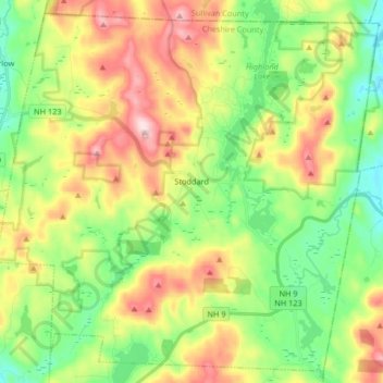
Name: Stoddard topographic map, elevation, terrain.
Location: Stoddard, Cheshire County, New Hampshire, United States (43.01892 -72.19954 43.13187 -72.03408)
Average elevation: 1,480 ft
Minimum elevation: 1,056 ft
Maximum elevation: 2,123 ft
Cheshire County trails, hiking, mountain biking, running and outdoor activities
Make a donation
Gear up for your next adventure:
As an Amazon Associate, this site earns from qualifying purchases at no extra cost to you.
Other topographic maps
Click on a map to view its topography, its elevation and its terrain.
West Chesterfield
United States > New Hampshire > Cheshire County > Chesterfield
Average elevation: 551 ft
Camp Notre Dame
United States > New Hampshire > Cheshire County > Chesterfield
Average elevation: 732 ft
Make a donation
Gear up for your next adventure:
As an Amazon Associate, this site earns from qualifying purchases at no extra cost to you.
Make a donation
Gear up for your next adventure:
As an Amazon Associate, this site earns from qualifying purchases at no extra cost to you.
Make a donation
Gear up for your next adventure:
As an Amazon Associate, this site earns from qualifying purchases at no extra cost to you.
Scotland
United States > New Hampshire > Cheshire County > Winchester > Scotland
Average elevation: 686 ft
Alstead Center
United States > New Hampshire > Cheshire County > Alstead > Alstead Center
Average elevation: 1,217 ft
Make a donation
Gear up for your next adventure:
As an Amazon Associate, this site earns from qualifying purchases at no extra cost to you.
Longmeadow Subdivision
United States > New Hampshire > Cheshire County > Keene
Average elevation: 587 ft