
Fayette County topographic map
Click on the map to display elevation.
About this map
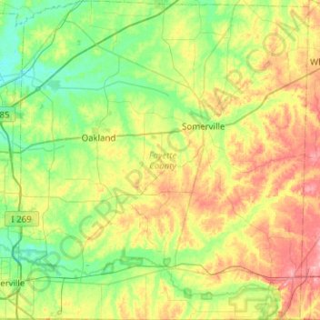
Name: Fayette County topographic map, elevation, terrain.
Location: Fayette County, West Tennessee, Tennessee, United States (34.99372 -89.64428 35.40480 -89.18394)
Average elevation: 397 ft
Minimum elevation: 259 ft
Maximum elevation: 663 ft
Tennessee trails, hiking, mountain biking, running and outdoor activities
Other topographic maps
Click on a map to view its topography, its elevation and its terrain.
Stone Door Big Creek Gulf Overlook
United States > Tennessee > Grundy County
Average elevation: 1,604 ft
Henderson Springs
United States > Tennessee > Sevier County > Pigeon Forge
Average elevation: 1,079 ft
Ridgedale
United States > Tennessee > Hamilton County > Chattanooga > Ridgeside
Average elevation: 768 ft
Barfield Crescent Park
United States > Tennessee > Rutherford County > Murfreesboro
Average elevation: 659 ft
Stonehenge Estates
United States > Tennessee > Williamson County > Brentwood
Average elevation: 840 ft
Cherokee Dam - Saddle Dam No. 1
United States > Tennessee > Jefferson County
Average elevation: 1,053 ft
Brainerd
United States > Tennessee > Hamilton County > Chattanooga > Ridgeside
Average elevation: 768 ft
Millersville City Park
United States > Tennessee > Robertson County > Millersville
Average elevation: 853 ft
Grassland Addition
United States > Tennessee > Cumberland County > Crossville
Average elevation: 1,837 ft