Geolocate

Pereira topographic map

Click on the map to display elevation.

About this map

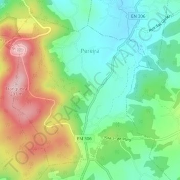
Name: Pereira topographic map, elevation, terrain.

Location: Pereira, Barcelos, Braga, 4755-404, Portugal (41.47717 -8.64642 41.49985 -8.61854)

Average elevation: 492 ft

Minimum elevation: 203 ft

Maximum elevation: 958 ft

Other topographic maps

Click on a map to view its topography, its elevation and its terrain.

Franqueira

Portugal > Braga > Barcelos

Average elevation: 479 ft

Silveiros

Portugal > Braga > Barcelos

Average elevation: 446 ft

Fonte Coberta

Portugal > Braga > Barcelos

Average elevation: 384 ft

Monte do Facho

Portugal > Braga > Barcelos > Roriz

Average elevation: 397 ft

Vila Cova

Portugal > Braga > Barcelos

Average elevation: 322 ft

Feitos

Portugal > Braga > Barcelos

Average elevation: 850 ft

Milhazes

Portugal > Braga > Barcelos

Average elevation: 272 ft

Vilar do Monte

Portugal > Braga > Barcelos

Average elevation: 541 ft

Gonçalo

Portugal > Braga > Barcelos

Average elevation: 1,138 ft

Martim de Além

Portugal > Braga > Barcelos > Martim

Average elevation: 440 ft

Durrães

Portugal > Braga > Barcelos

Average elevation: 433 ft

Gamil

Portugal > Braga > Barcelos

Average elevation: 223 ft

Gear up for your next adventure:

🪶Multi‑Purpose Knife - Useful blade for camp and trail
🎒Gear Packing Cubes - Organize your backpack efficiently
🛏️Cold Weather Sleeping Bag - Warm sleeping bag for cold conditions
👟Trail Running Shoes - Lightweight shoes for trail runners
🎒Hydration Pack - Hands‑free water reservoir for long hikes

As an Amazon Associate, this site earns from qualifying purchases at no extra cost to you.