
Make a donation
Gear up for your next adventure:
As an Amazon Associate, this site earns from qualifying purchases at no extra cost to you.
Al-ʿAbbāsiyyah Canal topographic map
Click on the map to display elevation.
Make a donation
Gear up for your next adventure:
As an Amazon Associate, this site earns from qualifying purchases at no extra cost to you.
About this map
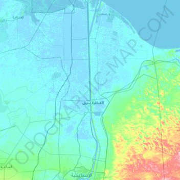
Name: Al-ʿAbbāsiyyah Canal topographic map, elevation, terrain.
Location: Al-ʿAbbāsiyyah Canal, Port Said, 41524, Egypt (30.58346 32.24480 31.23122 32.31484)
Average elevation: 52 ft
Minimum elevation: -16 ft
Maximum elevation: 515 ft
Make a donation
Gear up for your next adventure:
As an Amazon Associate, this site earns from qualifying purchases at no extra cost to you.
Other topographic maps
Click on a map to view its topography, its elevation and its terrain.
Make a donation
Gear up for your next adventure:
As an Amazon Associate, this site earns from qualifying purchases at no extra cost to you.
Make a donation
Gear up for your next adventure:
As an Amazon Associate, this site earns from qualifying purchases at no extra cost to you.