
Spokane topographic map
Interactive map
Click on the map to display elevation.
About this map
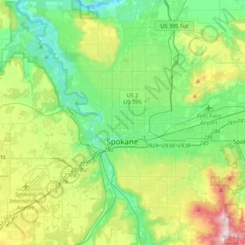
Name: Spokane topographic map, elevation, terrain.
Location: Spokane, Spokane County, Washington, United States (47.58678 -117.60400 47.75880 -117.30386)
Average elevation: 2,149 ft
Minimum elevation: 1,542 ft
Maximum elevation: 3,661 ft
Spokane is located on the Spokane River in eastern Washington at an elevation of 1,843 feet (562 m) above sea level, about 18 miles (29 km) from Idaho, 92 miles (148 km) south of the Canadian border, 229 miles (369 km) due east of Seattle, and 279 miles (449 km) southwest of Calgary. The lowest elevation in the city of Spokane is the northernmost point of the Spokane River within city limits (in Riverside State Park) at 1,608 feet (490 m); the highest elevation is on the northeast side, near the community of Hillyard (though closer to Beacon Hill and the North Hill Reservoir) at 2,591 feet (790 m). Spokane is part of the Inland Northwest region, consisting of eastern Washington, north Idaho, northwestern Montana, and northeastern Oregon. The city has a total area of 60.02 square miles (155.45 km2), of which 59.25 square miles (153.46 km2) is land and 0.77 square miles (1.99 km2) is water.
Other topographic maps
Click on a map to view its topography, its elevation and its terrain.
Newman Lake
United States > Washington > Spokane County
Newman Lake, Spokane County, Washington, 99025, United States
Average elevation: 2,169 ft
Hog Lake
United States > Washington > Spokane County
Hog Lake, Spokane County, Washington, United States
Average elevation: 2,178 ft
Silver Lake
United States > Washington > Spokane County
Silver Lake, Spokane County, Washington, 99022, United States
Average elevation: 2,431 ft
Mead
United States > Washington > Spokane County
Mead, Spokane County, Washington, 99021, United States
Average elevation: 1,919 ft
Country Homes
United States > Washington > Spokane County
Country Homes, Spokane County, Washington, 99251, United States
Average elevation: 1,965 ft
Airway Heights
United States > Washington > Spokane County
Airway Heights, Spokane County, Washington, 99001, United States
Average elevation: 2,375 ft
Millwood
United States > Washington > Spokane County
Millwood, Spokane County, Washington, United States
Average elevation: 1,969 ft
Cheney
United States > Washington > Spokane County
Cheney, Spokane County, Washington, United States
Average elevation: 2,388 ft
Deer Park
United States > Washington > Spokane County
Deer Park, Spokane County, Washington, 99006, United States
Average elevation: 2,159 ft
Mount Spokane
United States > Washington > Spokane County
Mount Spokane, Spokane County, Washington, United States
Average elevation: 4,839 ft
Liberty Lake
United States > Washington > Spokane County
Liberty Lake, Spokane County, Washington, 99019, United States
Average elevation: 2,113 ft
Spokane Valley
United States > Washington > Spokane County
Spokane Valley, Spokane County, Washington, United States
Average elevation: 2,208 ft
Nine Mile Falls
United States > Washington > Spokane County
Nine Mile Falls, Spokane County, Washington, 99026, United States
Average elevation: 1,759 ft
Riverside State Park
United States > Washington > Spokane County > Spokane
Riverside State Park, Spokane, Spokane County, Washington, United States
Average elevation: 2,116 ft
Medical Lake
United States > Washington > Spokane County
Medical Lake, Spokane County, Washington, 99022, United States
Average elevation: 2,421 ft
Medical Lake
United States > Washington > Spokane County > Medical Lake > Medical Lake
Medical Lake, Spokane County, Washington, 99022, United States
Average elevation: 2,451 ft
Chattaroy
United States > Washington > Spokane County > Chattaroy
Chattaroy, Spokane County, Washington, 99005, United States
Average elevation: 1,834 ft