
Make a donation
Gear up for your next adventure:
As an Amazon Associate, this site earns from qualifying purchases at no extra cost to you.
Dharan topographic map
Click on the map to display elevation.
Make a donation
Gear up for your next adventure:
As an Amazon Associate, this site earns from qualifying purchases at no extra cost to you.
Dharan
Dharan is situated on the foothills of the Mahabharat Range in the north with its southern tip touching the edge of the Terai region at an altitude of 1148 ft (349m). Dharan bazaar grew up near Phusre where the old walking route to Dhankuta and a large part of the Eastern hills left the plains with the ascent of Sanghuri Danra. In the days when villagers in the hills made their annual trek to sell and buy goods this was a natural location for a market where hills and Terai met. In 1952 the construction of the Kosi barrage began and a narrow gauge railway was built to take stone from Phusre loaded at a locality now known as "Railway" to the site of the barrage near the Indian Border. The Koshi highway runs through the heart of the city thus connecting it with the provincial capital of Biratnagar as well as the Itahari junction of the east–west Mahendra highway (lying 41 km and 17 km south, respectively), and the Nepal-China border of Kimathanka (lying 115 km north). The road from Biratnagar was originally built and surfaced in connection with the building of Ghopa Camp for the British Gurkhas. The road from Dharan to Dhankuta was financed by the UK and largely completed by 1982.
Make a donation
Gear up for your next adventure:
As an Amazon Associate, this site earns from qualifying purchases at no extra cost to you.
About this map
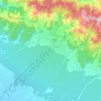
Name: Dharan topographic map, elevation, terrain.
Location: Dharan, Sunsari, Koshi Province, 56700, Nepal (26.71205 87.19811 26.87889 87.35381)
Average elevation: 1,568 ft
Minimum elevation: 335 ft
Maximum elevation: 6,155 ft
Make a donation
Gear up for your next adventure:
As an Amazon Associate, this site earns from qualifying purchases at no extra cost to you.
Other topographic maps
Click on a map to view its topography, its elevation and its terrain.