
Island Park topographic map
Click on the map to display elevation.
Island Park
Island Park is located at 44°29′59″N 111°20′19″W / 44.49972°N 111.33861°W / 44.49972; -111.33861 (44.4996, −111.3387), at an elevation of 6,293 feet (1,918 m) above sea level, making it the highest city in Idaho.
About this map
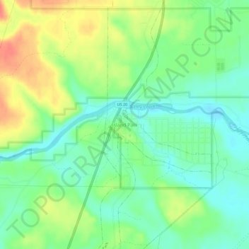
Name: Island Park topographic map, elevation, terrain.
Location: Island Park, Fremont County, Idaho, 83433, United States (44.47782 -111.35574 44.51782 -111.31574)
Average elevation: 6,437 ft
Minimum elevation: 6,368 ft
Maximum elevation: 6,535 ft
Fremont County trails, hiking, mountain biking, running and outdoor activities
Other topographic maps
Click on a map to view its topography, its elevation and its terrain.
Newdale
United States > Idaho > Fremont County
Newdale is the nearest city to the Teton Dam, which failed on June 5, 1976. Newdale did not receive any flooding or damage, due to its elevation and position relative to the dam.
Average elevation: 5,085 ft
American Legion / Daughters of Utah Pioneers Park
United States > Idaho > Fremont County > St. Anthony
Average elevation: 4,970 ft