Geolocate

Somerton topographic map

Click on the map to display elevation.

About this map

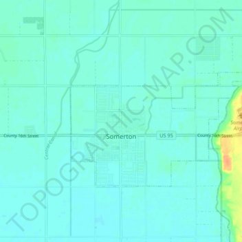
Name: Somerton topographic map, elevation, terrain.

Location: Somerton, Yuma County, Arizona, 85350, United States (32.58185 -114.72718 32.61970 -114.64406)

Average elevation: 108 ft

Minimum elevation: 92 ft

Maximum elevation: 197 ft

Yuma County trails, hiking, mountain biking, running and outdoor activities

Other topographic maps

Click on a map to view its topography, its elevation and its terrain.

Dateland

United States > Arizona > Yuma County

Average elevation: 453 ft

Hyder

United States > Arizona > Yuma County

Average elevation: 568 ft

Palomas

United States > Arizona > Yuma County

Average elevation: 410 ft

Araby

United States > Arizona > Yuma County > Yuma

Average elevation: 197 ft

Laguna Mountains

United States > Arizona > Yuma County

Average elevation: 463 ft

Tuscan Ranch

United States > Arizona > Yuma County > Yuma

Average elevation: 207 ft

Noah

United States > Arizona > Yuma County

Average elevation: 348 ft

Gear up for your next adventure:

🪶LED Camping Lantern - Bright lantern for camp lighting
🎒Outdoor Daypacks - Lightweight backpacks designed for carrying maps and essential gear
🎒Waterproof Dry Bags - Keep your electronics and maps dry inside your pack
☀️Outdoor Sunscreen - High protection sunscreen for outdoor activities
🎒Trail Energy Bars - High‑calorie bars for hiking energy

As an Amazon Associate, this site earns from qualifying purchases at no extra cost to you.