Geolocate

Biswanath topographic map

Click on the map to display elevation.

About this map

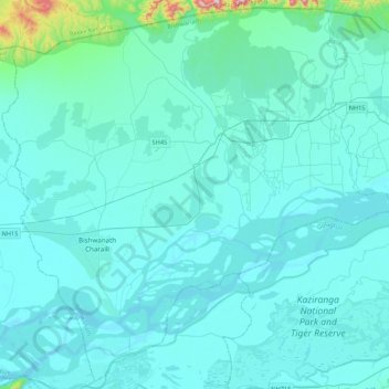
Name: Biswanath topographic map, elevation, terrain.

Location: Biswanath, Bishwanath, Assam, India (26.59375 93.04446 26.96111 93.47251)

Average elevation: 325 ft

Minimum elevation: 187 ft

Maximum elevation: 2,175 ft

Other topographic maps

Click on a map to view its topography, its elevation and its terrain.

Tezpur

India > Assam > Tezpur

Average elevation: 223 ft

Jorabat

India > Assam > Sonapur

Average elevation: 499 ft

Subansiri

India > Assam > Gogamukh

Average elevation: 315 ft

Kāmrūp

India > Assam

Average elevation: 1,083 ft

Diphu

India > Assam > Diphu

Diphu is located at 25°50′N 93°26′E / 25.83°N 93.43°E / 25.83; 93.43. It has an average elevation of 186 metres (610 feet). It is about 270 km by road and 213 km by railways from Guwahati. The town is located on a beautiful hill.

Average elevation: 630 ft

Badarpur

India > Assam > Badarpur > Badarpur

Average elevation: 89 ft

Numaligarh

India > Assam > Bokakhat > Numaligarh

Average elevation: 285 ft

Gear up for your next adventure:

🏥Hiking First Aid Kits - Comprehensive medical kits for remote trail injuries
🏫Relief Map Kits - Hands-on tools for teaching landforms and elevation
🧴Hand Sanitizer - Keep hands clean while hiking
☀️Outdoor Sunscreen - High protection sunscreen for outdoor activities
🛠️Outdoor Gear Repair Kit - Essential tools to fix gear on the trail

As an Amazon Associate, this site earns from qualifying purchases at no extra cost to you.