
Make a donation
Gear up for your next adventure:
As an Amazon Associate, this site earns from qualifying purchases at no extra cost to you.
Xinzheng topographic map
Click on the map to display elevation.
Make a donation
Gear up for your next adventure:
As an Amazon Associate, this site earns from qualifying purchases at no extra cost to you.
About this map
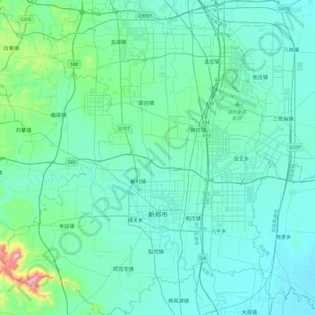
Name: Xinzheng topographic map, elevation, terrain.
Location: Xinzheng, Zhengzhou, Henan, China (34.27552 113.50471 34.65340 113.89991)
Average elevation: 495 ft
Minimum elevation: 246 ft
Maximum elevation: 2,507 ft
Make a donation
Gear up for your next adventure:
As an Amazon Associate, this site earns from qualifying purchases at no extra cost to you.
Other topographic maps
Click on a map to view its topography, its elevation and its terrain.
Anyang
Anyang spans a total area of 7,355 square kilometres (2,840 sq mi). The city's elevation is generally higher in the west, with the foothills of the Taihang Mountains running through the area, and lower in the east, which comprises part of the North China Plain.
Average elevation: 335 ft
Make a donation
Gear up for your next adventure:
As an Amazon Associate, this site earns from qualifying purchases at no extra cost to you.