
Make a donation
Gear up for your next adventure:
As an Amazon Associate, this site earns from qualifying purchases at no extra cost to you.
Saint-Robert-Bellarmin topographic map
Click on the map to display elevation.
Make a donation
Gear up for your next adventure:
As an Amazon Associate, this site earns from qualifying purchases at no extra cost to you.
About this map
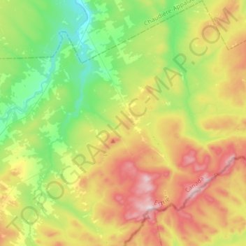
Name: Saint-Robert-Bellarmin topographic map, elevation, terrain.
Average elevation: 1,529 ft
Minimum elevation: 843 ft
Maximum elevation: 2,602 ft
Make a donation
Gear up for your next adventure:
As an Amazon Associate, this site earns from qualifying purchases at no extra cost to you.
Other topographic maps
Click on a map to view its topography, its elevation and its terrain.
Mont Gosford
Canada > Quebec > Le Granit > Saint-Augustin-de-Woburn
Since 1978, Mount Gosford is included in "ZEC Louise-Gosford", a controlled harvesting zone open to the public. Recently, the areas at more than 700 metres of altitude were designated Important Bird Areas due to the presence Bicknell's thrushes, an endemic species living in mountain peaks of northeast North…
Average elevation: 3,061 ft