
Rosliston topographic map
Click on the map to display elevation.
About this map
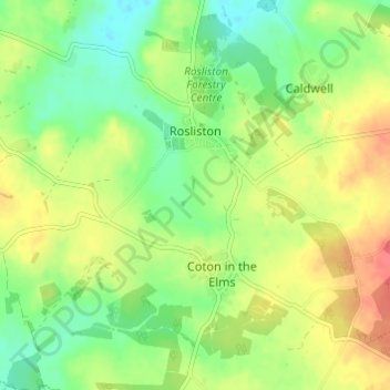
Name: Rosliston topographic map, elevation, terrain.
Average elevation: 266 ft
Minimum elevation: 190 ft
Maximum elevation: 354 ft
Other topographic maps
Click on a map to view its topography, its elevation and its terrain.
Robin Wood
United Kingdom > England > Derbyshire > South Derbyshire > Stanton by Bridge CP
Average elevation: 302 ft
Pistern Hill
United Kingdom > England > Derbyshire > South Derbyshire > Smisby
Average elevation: 499 ft
Repton Shrubs
United Kingdom > England > Derbyshire > South Derbyshire > Repton CP
Average elevation: 361 ft
Newhall Wood
United Kingdom > England > Derbyshire > South Derbyshire > Newhall
Average elevation: 285 ft
Staunton Harold Reservoir
United Kingdom > England > Derbyshire > South Derbyshire > Melbourne CP
Average elevation: 305 ft
Linton Heath
United Kingdom > England > Derbyshire > South Derbyshire > Linton
Average elevation: 331 ft
Foremark Reservoir
United Kingdom > England > Derbyshire > South Derbyshire > Foremark CP
Average elevation: 390 ft
Botany Bay
United Kingdom > England > Derbyshire > South Derbyshire > Rosliston
Average elevation: 312 ft
Mercia Marina
United Kingdom > England > Derbyshire > South Derbyshire > Willington CP
Average elevation: 167 ft
Gorsey Leys
United Kingdom > England > Derbyshire > South Derbyshire > Stanton by Bridge CP
Average elevation: 331 ft
Elvaston Castle
United Kingdom > England > Derbyshire > South Derbyshire > Elvaston
Average elevation: 135 ft
Calke Park (National Trust)
United Kingdom > England > Derbyshire > South Derbyshire > Calke CP
Average elevation: 322 ft