
Make a donation
Gear up for your next adventure:
As an Amazon Associate, this site earns from qualifying purchases at no extra cost to you.
Chugchillan topographic map
Click on the map to display elevation.
Make a donation
Gear up for your next adventure:
As an Amazon Associate, this site earns from qualifying purchases at no extra cost to you.
About this map
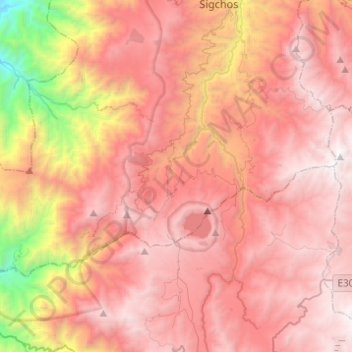
Name: Chugchillan topographic map, elevation, terrain.
Location: Chugchillan, Sigchos, Cotopaxi, Ecuador (-0.89499 -79.11735 -0.75441 -78.87170)
Average elevation: 10,361 ft
Minimum elevation: 3,898 ft
Maximum elevation: 14,042 ft
Make a donation
Gear up for your next adventure:
As an Amazon Associate, this site earns from qualifying purchases at no extra cost to you.
Other topographic maps
Click on a map to view its topography, its elevation and its terrain.
Make a donation
Gear up for your next adventure:
As an Amazon Associate, this site earns from qualifying purchases at no extra cost to you.
Make a donation
Gear up for your next adventure:
As an Amazon Associate, this site earns from qualifying purchases at no extra cost to you.
Las Minas de la Plata
Ecuador > Cotopaxi > Sigchos > Palo Quemado > Las Minas de la Plata
Average elevation: 4,380 ft
Make a donation
Gear up for your next adventure:
As an Amazon Associate, this site earns from qualifying purchases at no extra cost to you.