
Make a donation
Gear up for your next adventure:
As an Amazon Associate, this site earns from qualifying purchases at no extra cost to you.
Coplay topographic map
Click on the map to display elevation.
Make a donation
Gear up for your next adventure:
As an Amazon Associate, this site earns from qualifying purchases at no extra cost to you.
About this map
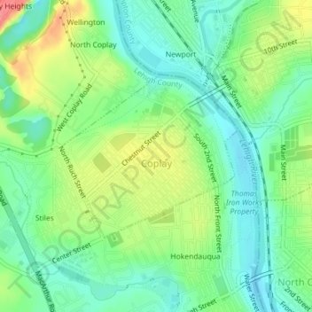
Name: Coplay topographic map, elevation, terrain.
Location: Coplay, Lehigh County, Pennsylvania, United States (40.66362 -75.50634 40.67777 -75.48609)
Average elevation: 351 ft
Minimum elevation: 266 ft
Maximum elevation: 499 ft
Lehigh County trails, hiking, mountain biking, running and outdoor activities
Make a donation
Gear up for your next adventure:
As an Amazon Associate, this site earns from qualifying purchases at no extra cost to you.
Other topographic maps
Click on a map to view its topography, its elevation and its terrain.
Hensingersville
United States > Pennsylvania > Lehigh County > Lower Macungie Township
Average elevation: 666 ft
Bake Oven Knob
United States > Pennsylvania > Lehigh County > Heidelberg Township
Average elevation: 1,017 ft
Walbert
United States > Pennsylvania > Lehigh County > South Whitehall Township
Average elevation: 449 ft
Crackersport
United States > Pennsylvania > Lehigh County > South Whitehall Township
Average elevation: 453 ft
Make a donation
Gear up for your next adventure:
As an Amazon Associate, this site earns from qualifying purchases at no extra cost to you.
Metamora Station
United States > Pennsylvania > Lehigh County > South Whitehall Township > Metamora Station
Average elevation: 410 ft
Old Zionsville
United States > Pennsylvania > Lehigh County > Upper Milford Township
Average elevation: 712 ft
Milford Park
United States > Pennsylvania > Lehigh County > Upper Milford Township
Average elevation: 725 ft
Make a donation
Gear up for your next adventure:
As an Amazon Associate, this site earns from qualifying purchases at no extra cost to you.
Laurys Station
United States > Pennsylvania > Lehigh County > North Whitehall Township
Average elevation: 499 ft
Neffs
United States > Pennsylvania > Lehigh County > North Whitehall Township
Average elevation: 682 ft
Make a donation
Gear up for your next adventure:
As an Amazon Associate, this site earns from qualifying purchases at no extra cost to you.