
Make a donation
Gear up for your next adventure:
As an Amazon Associate, this site earns from qualifying purchases at no extra cost to you.
Les Angles topographic map
Click on the map to display elevation.
Make a donation
Gear up for your next adventure:
As an Amazon Associate, this site earns from qualifying purchases at no extra cost to you.
Les Angles
Sur le plan historique et culturel, Les Angles fait partie de la région du Capcir, un haut plateau situé à plus de 1 400 m d'altitude, constitué d'une ancienne cuvette glaciaire resserrée entre les massifs granitiques du Carlit et du Madrès.
Make a donation
Gear up for your next adventure:
As an Amazon Associate, this site earns from qualifying purchases at no extra cost to you.
About this map
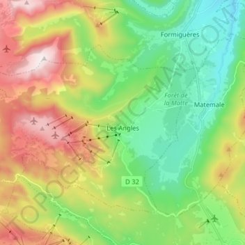
Name: Les Angles topographic map, elevation, terrain.
Average elevation: 5,968 ft
Minimum elevation: 4,688 ft
Maximum elevation: 8,110 ft
Make a donation
Gear up for your next adventure:
As an Amazon Associate, this site earns from qualifying purchases at no extra cost to you.
Other topographic maps
Click on a map to view its topography, its elevation and its terrain.
Font-Romeu
France > Occitanie > Pyrénées-Orientales > Font-Romeu-Odeillo-Via
Average elevation: 5,610 ft
Make a donation
Gear up for your next adventure:
As an Amazon Associate, this site earns from qualifying purchases at no extra cost to you.
Source du Tech
France > Occitanie > Pyrénées-Orientales > Prats-de-Mollo-la-Preste
Average elevation: 7,467 ft
Make a donation
Gear up for your next adventure:
As an Amazon Associate, this site earns from qualifying purchases at no extra cost to you.
Las Illas
France > Occitanie > Pyrénées-Orientales
Le pic des Salines, situé sur l'ancien territoire de Las Illas, est le point culminant de Maureillas-las-Illas à 1333 mètres d'altitude. Il marque la limite de commune avec Céret et la frontière entre l'Espagne et la France avec la commune de Maçanet de Cabrenys.
Average elevation: 2,264 ft
Make a donation
Gear up for your next adventure:
As an Amazon Associate, this site earns from qualifying purchases at no extra cost to you.
Hameau des Moulins
France > Occitanie > Pyrénées-Orientales > La Cabanasse
Average elevation: 5,220 ft
Col de la Llose
France > Occitanie > Pyrénées-Orientales > Ayguatébia-Talau
Average elevation: 5,945 ft
Make a donation
Gear up for your next adventure:
As an Amazon Associate, this site earns from qualifying purchases at no extra cost to you.
Robinet - Point d'eau
France > Occitanie > Pyrénées-Orientales > Latour-de-France
Average elevation: 512 ft
Col d'Ares
France > Occitanie > Pyrénées-Orientales > Prats-de-Mollo-la-Preste
Le col d'Ares (catalan : Coll d'Ares), à 1 512 ou 1 513 m d'altitude, est un col de montagne des Pyrénées, lieu de passage transfrontalier entre France et Espagne.
Average elevation: 4,554 ft
Château Royal de Collioure
France > Occitanie > Pyrénées-Orientales > Collioure
Average elevation: 135 ft
Make a donation
Gear up for your next adventure:
As an Amazon Associate, this site earns from qualifying purchases at no extra cost to you.
Phare du Cap Béar
France > Occitanie > Pyrénées-Orientales > Port-Vendres
En 1905, la première tour est abandonnée car trop souvent dans la brume. Le deuxième phare est construit d’une hauteur de 27 mètres à une altitude d’environ 50 mètres : son élévation est donc de 80 mètres au-dessus du niveau de la mer ; il est muni d'un feu à trois éclats blancs émis toutes les 20 secondes.
Average elevation: 43 ft
Saint-Martin-de-Fenollar
France > Occitanie > Pyrénées-Orientales > Maureillas-las-Illas
Average elevation: 449 ft
Col de la Perche
France > Occitanie > Pyrénées-Orientales > La Cabanasse > La Perche
Le col de la Perche (catalan : Coll de la Perxa), situé à 1 581 m d'altitude, est un col de montagne des Pyrénées, lieu de passage du Conflent vers la Cerdagne. Il se trouve sur la route des cols.
Average elevation: 5,276 ft
Make a donation
Gear up for your next adventure:
As an Amazon Associate, this site earns from qualifying purchases at no extra cost to you.
Brangoly
France > Occitanie > Pyrénées-Orientales > Enveitg
Brangolí se trouve en Cerdagne, une région de hauts plateaux située dans l'est des Pyrénées, à 1 450 m d'altitude. Le village se situe dans la vallée de la rivière de Brangolí, qui se jette dans l'Angoustrine.
Average elevation: 5,174 ft
Pla du Cambre d'Aze
France > Occitanie > Pyrénées-Orientales > Saint-Pierre-dels-Forcats
Average elevation: 6,526 ft
Make a donation
Gear up for your next adventure:
As an Amazon Associate, this site earns from qualifying purchases at no extra cost to you.
Make a donation
Gear up for your next adventure:
As an Amazon Associate, this site earns from qualifying purchases at no extra cost to you.
Caudiès-de-Fenouillèdes
France > Occitanie > Pyrénées-Orientales > Caudiès-de-Fenouillèdes > Caudiès-de-Fenouillèdes
Average elevation: 1,499 ft
Make a donation
Gear up for your next adventure:
As an Amazon Associate, this site earns from qualifying purchases at no extra cost to you.
Laroque-des-Albères
France > Occitanie > Pyrénées-Orientales > Laroque-des-Albères > Laroque-des-Albères
Average elevation: 554 ft
Le Barcarès
France > Occitanie > Pyrénées-Orientales > Le Barcarès > Le Barcarès
La superficie de la commune est de 1 165 hectares. L'altitude de la commune varie entre 0 et 4 mètres. Le centre du village est à une altitude de 2 m.
Average elevation: 3 ft
Amélie-les-Bains-Palalda
France > Occitanie > Pyrénées-Orientales > Amélie-les-Bains-Palalda > Amélie-les-Bains-Palalda
La superficie de la commune est de 2 943 hectares. L'altitude de la commune varie entre 176 et 1 424 mètres. Le centre d'Amélie-les-Bains est à une altitude de 219 m.
Average elevation: 1,394 ft
Molitg-les-Bains
France > Occitanie > Pyrénées-Orientales > Molitg-les-Bains > Molitg-les-Bains
Un espace protégé est présent sur la commune : le parc naturel régional des Pyrénées catalanes, créé en 2004 et d'une superficie de 139 062 ha, qui s'étend sur 66 communes du département. Ce territoire s'étage des fonds maraîchers et fruitiers des vallées de basse altitude aux plus hauts sommets…
Average elevation: 2,280 ft
Make a donation
Gear up for your next adventure:
As an Amazon Associate, this site earns from qualifying purchases at no extra cost to you.
Saint-Pierre-dels-Forcats
France > Occitanie > Pyrénées-Orientales > Saint-Pierre-dels-Forcats > Saint-Pierre-dels-Forcats
Saint-Pierre-dels-Forcats Écouter (en catalan Sant Pere dels Forcats) est une commune française, située dans le sud-ouest du département des Pyrénées-Orientales en région Occitanie. Ses habitants sont appelés les Pereforcatins. Sur le plan historique et culturel, la commune est dans la Cerdagne, une…
Average elevation: 5,315 ft
Station de Puyvalador
France > Occitanie > Pyrénées-Orientales > Puyvalador
Station de ski situé sur le territoire de la commune de Puyvalador dans le Capcir. L'altitude de la station varie entre 1 700 mètres et 2 382 mètres .
Average elevation: 5,801 ft
Make a donation
Gear up for your next adventure:
As an Amazon Associate, this site earns from qualifying purchases at no extra cost to you.
Château de Salveterra
France > Occitanie > Pyrénées-Orientales > Opoul-Périllos
Situé au sommet d'un plateau de 400 mètres d'altitude, l'édifice est destiné à héberger un village entier avec ses activités. Il est peu à peu abandonné au profit du village d'Opoul, et est au XXI siècle un monument ruiné accessible aux randonneurs.
Average elevation: 866 ft
Make a donation
Gear up for your next adventure:
As an Amazon Associate, this site earns from qualifying purchases at no extra cost to you.
Piló de Belmaig
France > Occitanie > Pyrénées-Orientales > Amélie-les-Bains-Palalda
Average elevation: 3,074 ft
Evol
France > Occitanie > Pyrénées-Orientales
Deux kilomètres au nord-ouest du bourg d'Olette, le hameau d'Évol est perché à 800 mètres d'altitude, surplombant la ribera d'Èvol. C'est un village typique dont les maisons aux murs de schiste sont recouvertes de lauzes.
Average elevation: 3,461 ft
Make a donation
Gear up for your next adventure:
As an Amazon Associate, this site earns from qualifying purchases at no extra cost to you.
Make a donation
Gear up for your next adventure:
As an Amazon Associate, this site earns from qualifying purchases at no extra cost to you.
Make a donation
Gear up for your next adventure:
As an Amazon Associate, this site earns from qualifying purchases at no extra cost to you.
Make a donation
Gear up for your next adventure:
As an Amazon Associate, this site earns from qualifying purchases at no extra cost to you.
Montou
France > Occitanie > Pyrénées-Orientales > Corbère-les-Cabanes
La superficie de la commune est de 1 272 hectares. L'altitude varie entre 118 et 520 mètres.
Average elevation: 591 ft
Phare solaire du Cap Cerbère
France > Occitanie > Pyrénées-Orientales > Cerbère > Mas Tounet
Average elevation: 66 ft
Make a donation
Gear up for your next adventure:
As an Amazon Associate, this site earns from qualifying purchases at no extra cost to you.
Les Orgues d'Ille-sur-Têt
France > Occitanie > Pyrénées-Orientales > Ille-sur-Têt
Le site des Orgues d’Ille-sur-Têt présente un relief particulier que l’on désigne sous le nom de cheminée de fée. Le site varie en altitude, entre ses points les plus bas et les plus élevés, d'environ 140 à 220 mètres d'altitude pour la partie orientale du site, et jusqu'à 244 mètres pour la partie occidentale.
Average elevation: 659 ft
La Font
France > Occitanie > Pyrénées-Orientales > Fontpédrouse > Prats-Balaguer
Average elevation: 4,639 ft
Make a donation
Gear up for your next adventure:
As an Amazon Associate, this site earns from qualifying purchases at no extra cost to you.
Fort Libéria
France > Occitanie > Pyrénées-Orientales > Villefranche-de-Conflent > Le Faubourg
Le fort Libéria a été construit par Vauban après le rattachement du Roussillon et d'une partie de la Cerdagne à la France par le traité des Pyrénées, à compter de 1681, en même temps que la citadelle de Mont-Louis située dans la partie supérieure de la vallée de la Têt, à 1 600 m d’altitude,…
Average elevation: 2,326 ft
Ancien château de la Roca d'Anyer
France > Occitanie > Pyrénées-Orientales > Nyer
Average elevation: 3,619 ft
Make a donation
Gear up for your next adventure:
As an Amazon Associate, this site earns from qualifying purchases at no extra cost to you.
Col de Fourtou
France > Occitanie > Pyrénées-Orientales > Prunet-et-Belpuig > Prunet
Entre Boule-d'Amont sur le Boulès et Calmeilles sur l'Ample, il se situe à 646 m d'altitude mais parfois indiqué à des altitudes supérieures.
Average elevation: 1,982 ft
Talau
France > Occitanie > Pyrénées-Orientales > Ayguatébia-Talau > Ayguatébia
La superficie de la commune de Talau est de 1 080 hectares. L'altitude du village est de 1 328 m.
Average elevation: 4,557 ft
Make a donation
Gear up for your next adventure:
As an Amazon Associate, this site earns from qualifying purchases at no extra cost to you.
Étang de la Balmette
France > Occitanie > Pyrénées-Orientales > Les Angles
Average elevation: 7,156 ft
Make a donation
Gear up for your next adventure:
As an Amazon Associate, this site earns from qualifying purchases at no extra cost to you.
La Forge del Mitg
France > Occitanie > Pyrénées-Orientales > Saint-Laurent-de-Cerdans
Average elevation: 2,290 ft
Make a donation
Gear up for your next adventure:
As an Amazon Associate, this site earns from qualifying purchases at no extra cost to you.
La Masou
France > Occitanie > Pyrénées-Orientales > Prats-de-Mollo-la-Preste
Average elevation: 3,199 ft
Angoustrine
France > Occitanie > Pyrénées-Orientales > Angoustrine-Villeneuve-des-Escaldes
Average elevation: 4,724 ft
Pic Carlit
France > Occitanie > Pyrénées-Orientales > Angoustrine-Villeneuve-des-Escaldes
Le pic Carlit (ou Puig Carlit) est un sommet métamorphique des Pyrénées françaises situé dans le massif du Carlit. C'est le point culminant du département des Pyrénées-Orientales avec une altitude de 2 921 mètres.
Average elevation: 8,461 ft
Make a donation
Gear up for your next adventure:
As an Amazon Associate, this site earns from qualifying purchases at no extra cost to you.
Fort du Serrat d'En Vaquer
France > Occitanie > Pyrénées-Orientales > Perpignan
Average elevation: 174 ft
Fort Lagarde
France > Occitanie > Pyrénées-Orientales > Prats-de-Mollo-la-Preste > La Masou
En 1307, on trouve trace d'une tour de surveillance bâtie en ces lieux, sous les rois d'Aragon, au lieudit « Lagardia ». Cette tour ronde, la « tour de la Guardia », ancienne tour à signaux, située à 1 540 mètres d'altitude, était destinée à communiquer des informations d'ordre militaire par le…
Average elevation: 2,927 ft
Make a donation
Gear up for your next adventure:
As an Amazon Associate, this site earns from qualifying purchases at no extra cost to you.
Retenue de Villeneuve-de-la-Raho
France > Occitanie > Pyrénées-Orientales > Villeneuve-de-la-Raho
Le lac trouve son origine dans une dépression, obstruée à l'est par une digue en terre. Le lac est situé à une altitude de 20 mètres.
Average elevation: 82 ft
Villeraze
France > Occitanie > Pyrénées-Orientales > Caudiès-de-Fenouillèdes
Average elevation: 1,923 ft
Plage naturiste du Bocal du Tech
France > Occitanie > Pyrénées-Orientales > Argelès-sur-Mer
Average elevation: 3 ft
Make a donation
Gear up for your next adventure:
As an Amazon Associate, this site earns from qualifying purchases at no extra cost to you.