Geolocate

Torch Cay topographic map

Click on the map to display elevation.

About this map

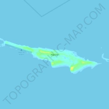
Name: Torch Cay topographic map, elevation, terrain.

Location: Torch Cay, Exuma, Bahamas (23.38624 -75.51097 23.40396 -75.45669)

Average elevation: 0 ft

Minimum elevation: 0 ft

Maximum elevation: 72 ft

Other topographic maps

Click on a map to view its topography, its elevation and its terrain.

Musha Cay

Bahamas > Exuma

Average elevation: 3 ft

Farmers Hill

Bahamas > Exuma

Average elevation: 13 ft

Cave Cay

Bahamas > Exuma

Average elevation: 3 ft

Darby Island

Bahamas > Exuma

Average elevation: 7 ft

Pipe Cay

Bahamas > Exuma

Average elevation: 3 ft

Hartswell

Bahamas > Exuma

Average elevation: 3 ft

Little Exuma Island

Bahamas > Exuma

Average elevation: 3 ft

Gear up for your next adventure:

🏥Hiking First Aid Kits - Comprehensive medical kits for remote trail injuries
🪶Survival Guide Book - Expert advice for emergency preparedness
📚USA Hiking Guide Books - Top trail guides and map books
🪓Survival Multi‑Tool - Versatile tool for camp and trail tasks
🗺️Topographic Maps - Detailed topo maps for hiking, exploring and outdoor navigation

As an Amazon Associate, this site earns from qualifying purchases at no extra cost to you.