Geolocate

Hartswell topographic map

Click on the map to display elevation.

About this map

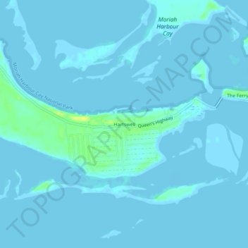
Name: Hartswell topographic map, elevation, terrain.

Location: Hartswell, Exuma, Bahamas (23.42759 -75.69581 23.46759 -75.65581)

Average elevation: 3 ft

Minimum elevation: -3 ft

Maximum elevation: 56 ft

Other topographic maps

Click on a map to view its topography, its elevation and its terrain.

Darby Island

Bahamas > Exuma

Average elevation: 7 ft

Cave Cay

Bahamas > Exuma

Average elevation: 3 ft

Lee Stocking Island

Bahamas > Exuma

Average elevation: 3 ft

Little Exuma Island

Bahamas > Exuma

Average elevation: 3 ft

Elizabeth Island

Bahamas > Exuma

Average elevation: 0 ft

Halls Pond Cay

Bahamas > Exuma

Average elevation: 3 ft

Pipe Cay

Bahamas > Exuma

Average elevation: 3 ft

Gear up for your next adventure:

🌄Hiking Binoculars - Compact binoculars for scenic views and trail spotting
🔌USB Car Charger - Car charger for on‑the‑go power needs
🔊Portable Camp Speaker - Music and alerts at camp
🧢Outdoor Hiking Hat - Sun protection hat for outdoor explorers
🛏️Cold Weather Sleeping Bag - Warm sleeping bag for cold conditions

As an Amazon Associate, this site earns from qualifying purchases at no extra cost to you.