Geolocate

Musha Cay topographic map

Click on the map to display elevation.

About this map

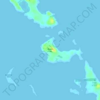
Name: Musha Cay topographic map, elevation, terrain.

Location: Musha Cay, Exuma, Bahamas (23.89096 -76.26630 23.89812 -76.25357)

Average elevation: 3 ft

Minimum elevation: 0 ft

Maximum elevation: 75 ft

Other topographic maps

Click on a map to view its topography, its elevation and its terrain.

Torch Cay

Bahamas > Exuma

Average elevation: 0 ft

Farmers Hill

Bahamas > Exuma

Average elevation: 13 ft

Halls Pond Cay

Bahamas > Exuma

Average elevation: 3 ft

Lee Stocking Island

Bahamas > Exuma

Average elevation: 3 ft

Hartswell

Bahamas > Exuma

Average elevation: 3 ft

Elizabeth Island

Bahamas > Exuma

Average elevation: 0 ft

Gear up for your next adventure:

🎒Gear Packing Cubes - Organize your backpack efficiently
🔭Telescopic Hiking Pole - Adjustable pole for hiking stability
🦶Carbon Trekking Poles - Reduce knee impact on steep descents with ultra-light poles
📻Weather Alert Radios - Stay informed of storm risks while off-the-grid
🎒Hydration Pack - Hands‑free water reservoir for long hikes

As an Amazon Associate, this site earns from qualifying purchases at no extra cost to you.