
Make a donation
Gear up for your next adventure:
As an Amazon Associate, this site earns from qualifying purchases at no extra cost to you.
Gavião topographic map
Click on the map to display elevation.
Make a donation
Gear up for your next adventure:
As an Amazon Associate, this site earns from qualifying purchases at no extra cost to you.
About this map
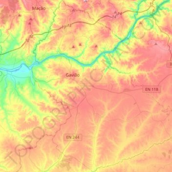
Name: Gavião topographic map, elevation, terrain.
Location: Gavião, Portalegre, Portugal (39.33406 -8.00888 39.56509 -7.74545)
Average elevation: 705 ft
Minimum elevation: 85 ft
Maximum elevation: 1,276 ft
Make a donation
Gear up for your next adventure:
As an Amazon Associate, this site earns from qualifying purchases at no extra cost to you.
Other topographic maps
Click on a map to view its topography, its elevation and its terrain.
Marvão
Portugal > Portalegre > Santa Maria de Marvão
Marvão é uma vila raiana portuguesa localizada no distrito de Portalegre, região Alentejo e sub-região do Alto Alentejo, com 398 habitantes, situada no topo da Serra do Sapoio, a uma altitude de 860 metros.
Average elevation: 1,827 ft
Make a donation
Gear up for your next adventure:
As an Amazon Associate, this site earns from qualifying purchases at no extra cost to you.
Make a donation
Gear up for your next adventure:
As an Amazon Associate, this site earns from qualifying purchases at no extra cost to you.
Make a donation
Gear up for your next adventure:
As an Amazon Associate, this site earns from qualifying purchases at no extra cost to you.
Make a donation
Gear up for your next adventure:
As an Amazon Associate, this site earns from qualifying purchases at no extra cost to you.
Make a donation
Gear up for your next adventure:
As an Amazon Associate, this site earns from qualifying purchases at no extra cost to you.
Nisa
Portugal > Portalegre > Espírito Santo, Nossa Senhora da Graça e São Simão
Average elevation: 915 ft
Make a donation
Gear up for your next adventure:
As an Amazon Associate, this site earns from qualifying purchases at no extra cost to you.
Make a donation
Gear up for your next adventure:
As an Amazon Associate, this site earns from qualifying purchases at no extra cost to you.
Make a donation
Gear up for your next adventure:
As an Amazon Associate, this site earns from qualifying purchases at no extra cost to you.
Albufeira do Poio
Portugal > Portalegre > Castelo de Vide > Nossa Senhora da Graça de Póvoa e Meadas
Average elevation: 997 ft
Make a donation
Gear up for your next adventure:
As an Amazon Associate, this site earns from qualifying purchases at no extra cost to you.
Make a donation
Gear up for your next adventure:
As an Amazon Associate, this site earns from qualifying purchases at no extra cost to you.
Anta da Aldeia da Mata
Portugal > Portalegre > Aldeia da Mata > Aldeia da Mata
Average elevation: 817 ft
Make a donation
Gear up for your next adventure:
As an Amazon Associate, this site earns from qualifying purchases at no extra cost to you.
São Salvador da Aramenha
Portugal > Portalegre > São Salvador da Aramenha > São Salvador da Aramenha
Average elevation: 1,959 ft
Make a donation
Gear up for your next adventure:
As an Amazon Associate, this site earns from qualifying purchases at no extra cost to you.
Câmara de Carga do Aproveitamento Hidroeléctrico de Bruceira
Portugal > Portalegre > Nisa
Average elevation: 846 ft
Make a donation
Gear up for your next adventure:
As an Amazon Associate, this site earns from qualifying purchases at no extra cost to you.