Geolocate

Buffalo topographic map

Click on the map to display elevation.

About this map

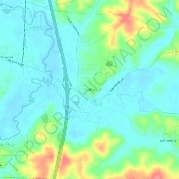
Name: Buffalo topographic map, elevation, terrain.

Location: Buffalo, Guernsey County, Ohio, 43722, United States (39.89591 -81.54012 39.93591 -81.50012)

Average elevation: 850 ft

Minimum elevation: 778 ft

Maximum elevation: 1,050 ft

Guernsey County trails, hiking, mountain biking, running and outdoor activities

Other topographic maps

Click on a map to view its topography, its elevation and its terrain.

Byesville

United States > Ohio > Guernsey County

Average elevation: 860 ft

Fairview

United States > Ohio > Guernsey County

Average elevation: 1,132 ft

Lore City

United States > Ohio > Guernsey County

Average elevation: 869 ft

Cumberland

United States > Ohio > Guernsey County

Average elevation: 902 ft

Gear up for your next adventure:

🧣Merino Neck Gaiters - Multi-functional headwear for wind and sun protection
🪶Camp Gear Gift Set - Perfect gift bundle for outdoor fans
🔊Portable Camp Speaker - Music and alerts at camp
🔥Camping Stove - Portable stove for camping and backcountry cooking
🪶Paracord Bracelet - Survival bracelet with built‑in tools

As an Amazon Associate, this site earns from qualifying purchases at no extra cost to you.