Geolocate

Cumberland topographic map

Click on the map to display elevation.

About this map

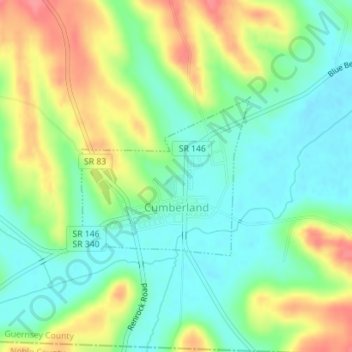
Name: Cumberland topographic map, elevation, terrain.

Location: Cumberland, Guernsey County, Ohio, United States (39.84830 -81.66715 39.86050 -81.65025)

Average elevation: 902 ft

Minimum elevation: 807 ft

Maximum elevation: 1,053 ft

Guernsey County trails, hiking, mountain biking, running and outdoor activities

Other topographic maps

Click on a map to view its topography, its elevation and its terrain.

North Salem

United States > Ohio > Guernsey County

Average elevation: 932 ft

Buffalo

United States > Ohio > Guernsey County

Average elevation: 850 ft

Derwent

United States > Ohio > Guernsey County

Average elevation: 843 ft

Elizabethtown

United States > Ohio > Guernsey County

Average elevation: 951 ft

Guernsey

United States > Ohio > Guernsey County

Average elevation: 915 ft

Kings Mine

United States > Ohio > Guernsey County

Average elevation: 889 ft

Kipling

United States > Ohio > Guernsey County

Average elevation: 892 ft

Londonderry

United States > Ohio > Guernsey County

Average elevation: 1,040 ft

Middlebourne

United States > Ohio > Guernsey County

Average elevation: 945 ft

East Cambridge

United States > Ohio > Guernsey County > Cambridge

Average elevation: 856 ft

Gear up for your next adventure:

🌡️Handheld Weather Meters - Measure wind, temp, and pressure for safe mountain travel
Solar GPS Watches - Advanced multisport watches with built-in topographic maps
💧Water Filtration Bottles - Safely drink from streams and lakes while exploring
🔌USB Car Charger - Car charger for on‑the‑go power needs
🎒Trail Energy Bars - High‑calorie bars for hiking energy

As an Amazon Associate, this site earns from qualifying purchases at no extra cost to you.