Geolocate

Fairview topographic map

Click on the map to display elevation.

About this map

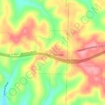
Name: Fairview topographic map, elevation, terrain.

Location: Fairview, Guernsey County, Ohio, 43736, United States (40.05195 -81.24054 40.06325 -81.22927)

Average elevation: 1,132 ft

Minimum elevation: 925 ft

Maximum elevation: 1,296 ft

Guernsey County trails, hiking, mountain biking, running and outdoor activities

Other topographic maps

Click on a map to view its topography, its elevation and its terrain.

East Cambridge

United States > Ohio > Guernsey County > Cambridge

Average elevation: 856 ft

Londonderry

United States > Ohio > Guernsey County

Average elevation: 1,040 ft

North Salem

United States > Ohio > Guernsey County

Average elevation: 932 ft

Buffalo

United States > Ohio > Guernsey County

Average elevation: 850 ft

Derwent

United States > Ohio > Guernsey County

Average elevation: 843 ft

Elizabethtown

United States > Ohio > Guernsey County

Average elevation: 951 ft

Guernsey

United States > Ohio > Guernsey County

Average elevation: 915 ft

Kings Mine

United States > Ohio > Guernsey County

Average elevation: 889 ft

Kipling

United States > Ohio > Guernsey County

Average elevation: 892 ft

Middlebourne

United States > Ohio > Guernsey County

Average elevation: 945 ft

Gear up for your next adventure:

⛑️Personal Locator Beacon - Safety beacon for emergencies
👖Convertible Hiking Pants - Versatile zip-off pants for changing altitudes and temperatures
🎒Day Hiking Backpack - Lightweight backpack perfect for day trips and outdoor adventures
Backpacking Tents - Weight-optimized shelters for multi-day topographic surveys
🛡️Bear Spray Outdoor - Protection in bear country hikes

As an Amazon Associate, this site earns from qualifying purchases at no extra cost to you.