Geolocate

Madison topographic map

Click on the map to display elevation.

About this map

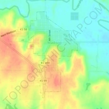
Name: Madison topographic map, elevation, terrain.

Location: Madison, Greenwood County, Kansas, 66860, United States (38.12188 -96.14457 38.14321 -96.12859)

Average elevation: 1,138 ft

Minimum elevation: 1,056 ft

Maximum elevation: 1,227 ft

Greenwood County trails, hiking, mountain biking, running and outdoor activities

Other topographic maps

Click on a map to view its topography, its elevation and its terrain.

Neal

United States > Kansas > Greenwood County

Average elevation: 1,001 ft

Piedmont

United States > Kansas > Greenwood County

Average elevation: 1,230 ft

Quincy

United States > Kansas > Greenwood County > Quincy

Average elevation: 965 ft

Gear up for your next adventure:

📻Weather Alert Radios - Stay informed of storm risks while off-the-grid
💧Water Filtration Bottles - Safely drink from streams and lakes while exploring
🎒Trekking Poles - Sturdy poles for balance and stability on rough terrain
🔋Rechargeable Batteries - Power up your outdoor devices
🚗GPS Dash Cams - Record your scenic drives through mountain passes and canyons

As an Amazon Associate, this site earns from qualifying purchases at no extra cost to you.