Geolocate

Neal topographic map

Click on the map to display elevation.

About this map

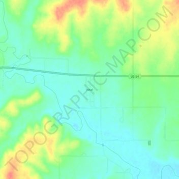
Name: Neal topographic map, elevation, terrain.

Location: Neal, Greenwood County, Kansas, 66863, United States (37.81420 -96.10027 37.85420 -96.06027)

Average elevation: 1,001 ft

Minimum elevation: 932 ft

Maximum elevation: 1,119 ft

Greenwood County trails, hiking, mountain biking, running and outdoor activities

Other topographic maps

Click on a map to view its topography, its elevation and its terrain.

Virgil

United States > Kansas > Greenwood County

Average elevation: 1,014 ft

Severy

United States > Kansas > Greenwood County

Average elevation: 1,109 ft

Madison

United States > Kansas > Greenwood County

Average elevation: 1,138 ft

Hamilton

United States > Kansas > Greenwood County

Average elevation: 1,109 ft

Eureka

United States > Kansas > Greenwood County

Average elevation: 1,119 ft

Climax

United States > Kansas > Greenwood County

Climax was founded in 1884. It was named from its elevation, or Climax College in Kalamazoo, Michigan.

Average elevation: 1,027 ft

Gear up for your next adventure:

🧣Hiking Neck Gaiter - Multi‑use neck protection for outdoor weather
Backpacking Tents - Weight-optimized shelters for multi-day topographic surveys
🧥Men's Rain Shells - Premium waterproof and breathable jackets for mountain weather
🦶Carbon Trekking Poles - Reduce knee impact on steep descents with ultra-light poles
📡GPS Antenna Upgrade - Enhance GPS reception in remote terrain

As an Amazon Associate, this site earns from qualifying purchases at no extra cost to you.