
Make a donation
Gear up for your next adventure:
As an Amazon Associate, this site earns from qualifying purchases at no extra cost to you.
Piedmont topographic map
Click on the map to display elevation.
Make a donation
Gear up for your next adventure:
As an Amazon Associate, this site earns from qualifying purchases at no extra cost to you.
About this map
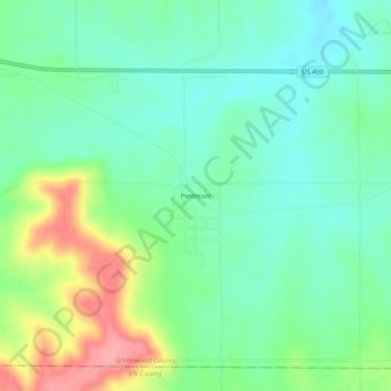
Name: Piedmont topographic map, elevation, terrain.
Location: Piedmont, Greenwood County, Kansas, 67122, United States (37.60364 -96.38556 37.64364 -96.34556)
Average elevation: 1,230 ft
Minimum elevation: 1,122 ft
Maximum elevation: 1,460 ft
Greenwood County trails, hiking, mountain biking, running and outdoor activities
Make a donation
Gear up for your next adventure:
As an Amazon Associate, this site earns from qualifying purchases at no extra cost to you.
Other topographic maps
Click on a map to view its topography, its elevation and its terrain.
Make a donation
Gear up for your next adventure:
As an Amazon Associate, this site earns from qualifying purchases at no extra cost to you.
Climax
United States > Kansas > Greenwood County
Climax was founded in 1884. It was named from its elevation, or Climax College in Kalamazoo, Michigan.
Average elevation: 1,027 ft