Geolocate

Veluwe topographic map

Click on the map to display elevation.

About this map

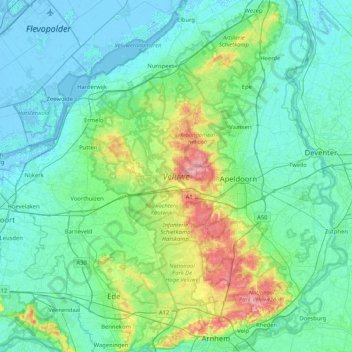
Name: Veluwe topographic map, elevation, terrain.

Location: Veluwe, Gelderland, Netherlands (51.96432 5.59772 52.47192 6.09318)

Average elevation: 59 ft

Minimum elevation: -23 ft

Maximum elevation: 354 ft

Other topographic maps

Click on a map to view its topography, its elevation and its terrain.

Slingeplas

Netherlands > Gelderland > Bredevoort

Average elevation: 95 ft

Elden

Netherlands > Gelderland > Arnhem

Average elevation: 36 ft

Veldhoek

Netherlands > Gelderland

Average elevation: 59 ft

Zwin

Netherlands > Gelderland > Bern > Bern

Average elevation: 10 ft

Arnhem

Netherlands > Gelderland > Arnhem

Average elevation: 79 ft

Ubbergen

Netherlands > Gelderland > Ubbergen > Ubbergen

Average elevation: 105 ft

Gear up for your next adventure:

🏕️Family Camping Gear - Essentials for group camping trips
🔥Camping Stove - Portable stove for camping and backcountry cooking
🪶Wildlife Field Guides - Learn animal tracking and species ID
🔋Solar Power Banks - Keep your GPS and phone charged in remote wilderness areas
🧭Orienteering Set - Complete compass and map reading kit

As an Amazon Associate, this site earns from qualifying purchases at no extra cost to you.