
Town of Arietta topographic map
Interactive map
Click on the map to display elevation.
About this map
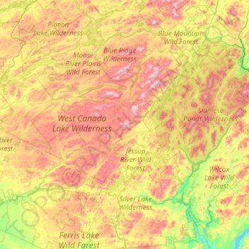
Name: Town of Arietta topographic map, elevation, terrain.
Location: Town of Arietta, Hamilton County, New York, United States (43.22823 -74.70538 43.93345 -74.45770)
Average elevation: 1,965 ft
Minimum elevation: 745 ft
Maximum elevation: 3,802 ft
Hamilton County trails, hiking, mountain biking, running and outdoor activities
Other topographic maps
Click on a map to view its topography, its elevation and its terrain.
Eagle Lake
United States > New York > Hamilton County > Town of Indian Lake > Eagle Nest
Average elevation: 1,890 ft
Grampus Lake
United States > New York > Hamilton County > Town of Long Lake
Average elevation: 1,860 ft
Sagamore Lake
United States > New York > Hamilton County > Town of Long Lake > Sagamore
Average elevation: 2,008 ft
Cedar River
United States > New York > Hamilton County > Town of Lake Pleasant
Average elevation: 2,503 ft
Three Ponds Mountain
United States > New York > Hamilton County > Town of Benson
Average elevation: 2,425 ft
Snowy Mountain
United States > New York > Hamilton County > Town of Indian Lake
Average elevation: 2,910 ft
Blue Mountain Lake
United States > New York > Hamilton County > Town of Indian Lake
Average elevation: 1,939 ft