
Make a donation
Gear up for your next adventure:
As an Amazon Associate, this site earns from qualifying purchases at no extra cost to you.
Averys Place topographic map
Click on the map to display elevation.
Make a donation
Gear up for your next adventure:
As an Amazon Associate, this site earns from qualifying purchases at no extra cost to you.
About this map
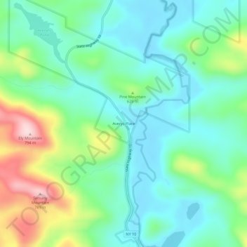
Name: Averys Place topographic map, elevation, terrain.
Average elevation: 1,886 ft
Minimum elevation: 1,617 ft
Maximum elevation: 2,575 ft
Hamilton County trails, hiking, mountain biking, running and outdoor activities
Make a donation
Gear up for your next adventure:
As an Amazon Associate, this site earns from qualifying purchases at no extra cost to you.
Other topographic maps
Click on a map to view its topography, its elevation and its terrain.
Cedar River
United States > New York > Hamilton County > Town of Lake Pleasant
Average elevation: 2,503 ft
Sacandaga Lake
United States > New York > Hamilton County > Town of Lake Pleasant
Average elevation: 1,742 ft
Village of Speculator
United States > New York > Hamilton County > Town of Lake Pleasant
Speculator Mountain, with an altitude of 2,966 feet (904 m), is south of the village.
Average elevation: 2,126 ft
Make a donation
Gear up for your next adventure:
As an Amazon Associate, this site earns from qualifying purchases at no extra cost to you.
Sagamore Lake
United States > New York > Hamilton County > Town of Long Lake > Sagamore
Average elevation: 2,008 ft
Make a donation
Gear up for your next adventure:
As an Amazon Associate, this site earns from qualifying purchases at no extra cost to you.
Brown Tract Pond Campground
United States > New York > Hamilton County > Town of Inlet
Average elevation: 1,850 ft
Grampus Lake
United States > New York > Hamilton County > Town of Long Lake
Average elevation: 1,860 ft
Make a donation
Gear up for your next adventure:
As an Amazon Associate, this site earns from qualifying purchases at no extra cost to you.
Eagle Lake
United States > New York > Hamilton County > Town of Indian Lake > Eagle Nest
Average elevation: 1,890 ft
Make a donation
Gear up for your next adventure:
As an Amazon Associate, this site earns from qualifying purchases at no extra cost to you.