Geolocate

Provedroux topographic map

Click on the map to display elevation.

About this map
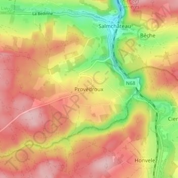
Name: Provedroux topographic map, elevation, terrain.

Location: Provedroux, Vielsalm, Bastogne, Luxembourg, Wallonia, 6671, Belgium (50.23129 5.87681 50.27129 5.91681)

Average elevation: 1,535 ft

Minimum elevation: 1,214 ft

Maximum elevation: 1,775 ft

Other topographic maps

Click on a map to view its topography, its elevation and its terrain.

Vielsalm

Belgium > Luxembourg > Bastogne

Average elevation: 1,552 ft

Bertogne

Belgium > Luxembourg > Bastogne > Bastogne

Average elevation: 1,358 ft

Bastogne

Belgium > Luxembourg > Bastogne

The municipality consists of the following districts: Bastogne, Longvilly, Noville, Villers-la-Bonne-Eau, and Wardin. The town is situated on a ridge in the Ardennes at an elevation of 510 metres (1,670 ft).

Average elevation: 1,522 ft
Tailles

Belgium > Luxembourg > Bastogne > Houffalize

Average elevation: 1,775 ft

Wibrin

Belgium > Luxembourg > Bastogne > Houffalize

Average elevation: 1,404 ft

Bastogne

Belgium > Luxembourg > Bastogne

The municipality consists of the following districts: Bastogne, Longvilly, Noville, Villers-la-Bonne-Eau, and Wardin. The town is situated on a ridge in the Ardennes at an elevation of 510 metres (1,670 ft).

Average elevation: 1,522 ft
Nives

Belgium > Luxembourg > Bastogne

Average elevation: 1,532 ft

Houffalize

Belgium > Luxembourg > Bastogne

Average elevation: 1,519 ft

Lavacherie

Belgium > Luxembourg > Bastogne

Average elevation: 1,450 ft

Fauvillers

Belgium > Luxembourg > Bastogne

Average elevation: 1,480 ft

Petit-Thier

Belgium > Luxembourg > Bastogne

Average elevation: 1,585 ft

Houffalize

Belgium > Luxembourg > Bastogne

Average elevation: 1,519 ft

Bihain

Belgium > Luxembourg > Bastogne > Vielsalm

Average elevation: 1,631 ft

Nadrin

Belgium > Luxembourg > Bastogne > Houffalize

Average elevation: 1,250 ft

Gouvy

Belgium > Luxembourg > Bastogne

Average elevation: 1,585 ft

Bastogne

Belgium > Luxembourg > Bastogne

The municipality consists of the following districts: Bastogne, Longvilly, Noville, Villers-la-Bonne-Eau, and Wardin. The town is situated on a ridge in the Ardennes at an elevation of 510 metres (1,670 ft).

Average elevation: 1,522 ft

Wibrin

Belgium > Luxembourg > Bastogne > Houffalize

Average elevation: 1,404 ft

Tillet

Belgium > Luxembourg > Bastogne

Average elevation: 1,526 ft

Noville

Belgium > Luxembourg > Bastogne > Bastogne

Average elevation: 1,549 ft

Flamierge

Belgium > Luxembourg > Bastogne > Bastogne

Average elevation: 1,407 ft

Gear up for your next adventure:

🌲Outdoor Survival Books - Best books on survival skills
🧥Waterproof Jacket for Hiking - Breathable and rugged rain jacket for outdoor excursions
🔪Outdoor Multitools - Essential survival tools for gear repair and field use
🔦Powerful Headlamps - Ultra-bright hands-free lighting for night navigation
🧥Men's Rain Shells - Premium waterproof and breathable jackets for mountain weather

As an Amazon Associate, this site earns from qualifying purchases at no extra cost to you.