Geolocate

Cotter topographic map

Click on the map to display elevation.

About this map

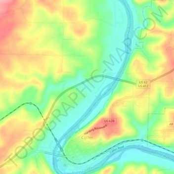
Name: Cotter topographic map, elevation, terrain.

Location: Cotter, Baxter County, Arkansas, United States (36.26286 -92.54425 36.30206 -92.50393)

Average elevation: 558 ft

Minimum elevation: 397 ft

Maximum elevation: 761 ft

Baxter County trails, hiking, mountain biking, running and outdoor activities

Other topographic maps

Click on a map to view its topography, its elevation and its terrain.

Gamaliel

United States > Arkansas > Baxter County

Average elevation: 751 ft

White River

United States > Arkansas > Baxter County

Average elevation: 486 ft

Old Joe

United States > Arkansas > Baxter County

Average elevation: 604 ft

Clarkridge

United States > Arkansas > Baxter County

Average elevation: 787 ft

Buffalo City

United States > Arkansas > Baxter County

Average elevation: 577 ft

Shady Grove

United States > Arkansas > Baxter County

Average elevation: 702 ft

Gear up for your next adventure:

👟Trail Running Shoes - Lightweight shoes for trail runners
☀️Outdoor Sunscreen - High protection sunscreen for outdoor activities
🛏️Cold Weather Sleeping Bag - Warm sleeping bag for cold conditions
🚪Portable Camp Chair - Foldable chair for comfort at camp
🔪Outdoor Multitools - Essential survival tools for gear repair and field use

As an Amazon Associate, this site earns from qualifying purchases at no extra cost to you.