
Burlington topographic map
Click on the map to display elevation.
Burlington
Burlington rests on diverse terrain influenced by Lake Champlain and glacial history, with an elevation averaging around 197 feet above sea level. The city spans relatively flat expanses in the Champlain Valley but also features gradual inclines and steeper slopes, especially near the lake's edge and downtown areas. The topography includes gentle hills and a few significant rises as you move away from the lake, which have shaped urban development and offer panoramic views across the lake to the Adirondacks. This terrain also supports a variety of ecosystems, from low-lying wetland areas to elevated forested spots, allowing for a range of habitats that thrive within Burlington's landscape. Detailed elevation layers reveal nuanced terrain changes, from hillshades to slopes that aid in water drainage and determine local vegetation patterns, as seen in natural areas like Centennial Woods. The city’s varied elevations play a key role in infrastructure planning, stormwater management, and recreational layout, emphasizing the practical and ecological impact of Burlington’s topography.
About this map
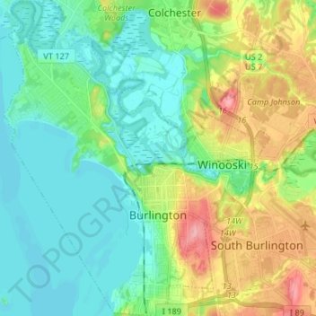
Name: Burlington topographic map, elevation, terrain.
Location: Burlington, Chittenden County, Vermont, United States (44.44591 -73.27704 44.53988 -73.17613)
Average elevation: 194 ft
Minimum elevation: 82 ft
Maximum elevation: 453 ft
Chittenden County trails, hiking, mountain biking, running and outdoor activities
Other topographic maps
Click on a map to view its topography, its elevation and its terrain.
Heineberg Bridge Fishing Wilderness Access
United States > Vermont > Chittenden County
Average elevation: 128 ft
Mount Mansfield
United States > Vermont > Chittenden County > Underhill
Mount Mansfield is the highest mountain in Vermont, reaching an elevation of 4,393 feet (1,339 m) above sea level. Located in the northwest of the state, it is also the highest peak in the Green Mountains. Its summit is located within the town of Underhill in Chittenden County; the ridgeline, including some…
Average elevation: 2,999 ft
Camels Hump
United States > Vermont > Chittenden County > Huntington
The summit of Camel's Hump is home to 10 acres (4 ha) of alpine tundra vegetation. Common plants found in this area include: Bigelow's sedge (Carex bigelowii), alpine bilberry (Vaccinium uliginosum), mountain sandwort (Minuartia groenlandica), crowberry (Empetrum nigrum), mountain cranberry (Vaccinium…
Average elevation: 2,766 ft
Mount Mansfield
United States > Vermont > Chittenden County > Underhill
Mount Mansfield is the highest mountain in Vermont, reaching an elevation of 4,393 feet (1,339 m) above sea level. Located in the northwest of the state, it is also the highest peak in the Green Mountains. Its summit is located within the town of Underhill in Chittenden County; the ridgeline, including some…
Average elevation: 2,999 ft
Arrowhead Mountain Lake
United States > Vermont > Chittenden County > Milton
Average elevation: 430 ft