
Delta Park topographic map
Click on the map to display elevation.
About this map
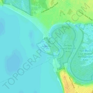
Name: Delta Park topographic map, elevation, terrain.
Average elevation: 105 ft
Minimum elevation: 85 ft
Maximum elevation: 171 ft
Chittenden County trails, hiking, mountain biking, running and outdoor activities
Other topographic maps
Click on a map to view its topography, its elevation and its terrain.
Burlington
United States > Vermont > Chittenden County
Burlington rests on diverse terrain influenced by Lake Champlain and glacial history, with an elevation averaging around 197 feet above sea level. The city spans relatively flat expanses in the Champlain Valley but also features gradual inclines and steeper slopes, especially near the lake's edge and downtown…
Average elevation: 194 ft
Underhill
United States > Vermont > Chittenden County
Underhill is home to the highest summit within the state, Mount Mansfield, which has a peak elevation of 4,393 feet (1,339 m) above sea level.
Average elevation: 978 ft
Heineberg Bridge Fishing Wilderness Access
United States > Vermont > Chittenden County
Average elevation: 128 ft
Mount Mansfield
United States > Vermont > Chittenden County > Underhill
Mount Mansfield is the highest mountain in Vermont, reaching an elevation of 4,393 feet (1,339 m) above sea level. Located in the northwest of the state, it is also the highest peak in the Green Mountains. Its summit is located within the town of Underhill in Chittenden County; the ridgeline, including some…
Average elevation: 2,999 ft
Camels Hump
United States > Vermont > Chittenden County > Huntington
The summit of Camel's Hump is home to 10 acres (4 ha) of alpine tundra vegetation. Common plants found in this area include: Bigelow's sedge (Carex bigelowii), alpine bilberry (Vaccinium uliginosum), mountain sandwort (Minuartia groenlandica), crowberry (Empetrum nigrum), mountain cranberry (Vaccinium…
Average elevation: 2,766 ft
Lake Iroquois
United States > Vermont > Chittenden County > Williston
Lake Surface Area: 247 acres Drainage Basin Area: 2, 418 acres Maximum Depth: 37 ft. Average Depth: 19 ft. Elevation: 685 ft.
Average elevation: 843 ft
Underhill
United States > Vermont > Chittenden County
Underhill is home to the highest summit within the state, Mount Mansfield, which has a peak elevation of 4,393 feet (1,339 m) above sea level.
Average elevation: 1,230 ft
Camels Hump
United States > Vermont > Chittenden County > Huntington
The summit of Camel's Hump is home to 10 acres (4 ha) of alpine tundra vegetation. Common plants found in this area include: Bigelow's sedge (Carex bigelowii), alpine bilberry (Vaccinium uliginosum), mountain sandwort (Minuartia groenlandica), crowberry (Empetrum nigrum), mountain cranberry (Vaccinium…
Average elevation: 2,766 ft
Mount Mansfield
United States > Vermont > Chittenden County > Underhill
Mount Mansfield is the highest mountain in Vermont, reaching an elevation of 4,393 feet (1,339 m) above sea level. Located in the northwest of the state, it is also the highest peak in the Green Mountains. Its summit is located within the town of Underhill in Chittenden County; the ridgeline, including some…
Average elevation: 2,999 ft
Lake Iroquois
United States > Vermont > Chittenden County > Williston
Lake Surface Area: 247 acres Drainage Basin Area: 2, 418 acres Maximum Depth: 37 ft. Average Depth: 19 ft. Elevation: 685 ft.
Average elevation: 843 ft