
云雾山镇 topographic map
Interactive map
Click on the map to display elevation.
About this map
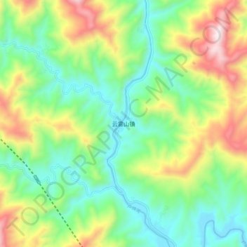
Name: 云雾山镇 topographic map, elevation, terrain.
Location: 云雾山镇, Chaotian, Guangyuan, Sichuan, China (32.61905 105.71987 32.69905 105.79987)
Average elevation: 2,713 ft
Minimum elevation: 1,637 ft
Maximum elevation: 4,770 ft
Other topographic maps
Click on a map to view its topography, its elevation and its terrain.
འབར་ཁམས་རྫོང་ 马尔康市
འབར་ཁམས་རྫོང་ 马尔康市, 阿坝藏族羌族自治州, Sichuan, China
Average elevation: 12,657 ft
银多乡
China > Sichuan > ཉག་རོང་རྫོང་ 新龙县
银多乡, ཉག་རོང་རྫོང་ 新龙县, 甘孜藏族自治州, Sichuan, China
Average elevation: 14,239 ft