
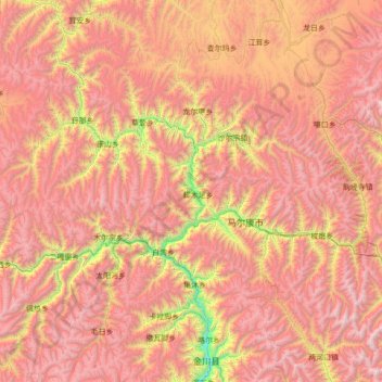
འབར་ཁམས་རྫོང་ 马尔康市 topographic map
Interactive map
Click on the map to display elevation.
About this map
Name: འབར་ཁམས་རྫོང་ 马尔康市 topographic map, elevation, terrain.
Location: འབར་ཁམས་རྫོང་ 马尔康市, 阿坝藏族羌族自治州, Sichuan, China (31.59044 101.28131 32.40837 102.67333)
Average elevation: 12,657 ft
Minimum elevation: 6,988 ft
Maximum elevation: 17,772 ft
Das Territorium von Barkam liegt auf Höhen zwischen 2180 und 5301 Metern über Normalnull. Es fällt von Nordosten nach Südwesten leicht ab. Die Jahresdurchschnittstemperaturen liegen zwischen 8 und 9 °C mit 120 frostfreien Tagen pro Jahr. Barkam erhält im Mittel Niederschläge von 753 Millimetern und 2000 Sonnenstunden pro Jahr. Barkam wird von 3 großen und 69 kleinen Flüssen durchzogen, die größtenteils eine hohe Flussgeschwindigkeit haben und gemeinsam ein theoretisches Potential von 7,2 Gigawatt Leistung hätten.
Other topographic maps
Click on a map to view its topography, its elevation and its terrain.
银多乡
China > Sichuan > ཉག་རོང་རྫོང་ 新龙县
银多乡, ཉག་རོང་རྫོང་ 新龙县, 甘孜藏族自治州, Sichuan, China
Average elevation: 14,239 ft