Geolocate

Helechal topographic map

Click on the map to display elevation.

About this map

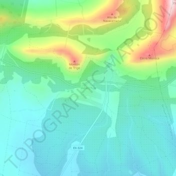
Name: Helechal topographic map, elevation, terrain.

Location: Helechal, Benquerencia de la Serena, Badajoz, Extremadura, Spain (38.65080 -5.39048 38.69080 -5.35048)

Average elevation: 2,024 ft

Minimum elevation: 1,640 ft

Maximum elevation: 3,110 ft

Other topographic maps

Click on a map to view its topography, its elevation and its terrain.

Cáceres

Spain > Extremadura

Average elevation: 1,811 ft

Plasencia

Spain > Extremadura

Average elevation: 1,302 ft

Guadalupe

Spain > Extremadura

The Guadalupe River has its origins near the town in the Sierra de las Villuercas. Its highest point, the Pico la Villuerca reaches an altitude of 1603 m.

Average elevation: 2,503 ft

Almendralejo

Spain > Extremadura > Tierra de Barros

Average elevation: 1,089 ft

Campanario

Spain > Extremadura

Average elevation: 1,161 ft

Talayuela

Spain > Extremadura

Talayuela is located in the north-east part of Extremadura autonomous community, in Tiétar river valley, an important tributary of Tagus river, and belongs to Campo Arañuelo comarca, next to La Vera comarca. That land is almost a flat valley, with an altitude of 287 meters above sea level.

Average elevation: 997 ft

Alange

Spain > Extremadura

Average elevation: 1,043 ft

Valverde del Fresno

Spain > Extremadura

Average elevation: 1,903 ft

Valdelacalzada

Spain > Extremadura > Tierra de Badajoz

Average elevation: 614 ft

Serradilla

Spain > Extremadura

Average elevation: 1,240 ft

Mata de Alcántara

Spain > Extremadura

Average elevation: 1,070 ft

Mérida

Spain > Extremadura

Average elevation: 958 ft

Rena

Spain > Extremadura

Average elevation: 876 ft

Villarta de los Montes

Spain > Extremadura

Average elevation: 1,995 ft

Toril

Spain > Extremadura > Campo Arañuelo

Average elevation: 896 ft

Trujillo

Spain > Extremadura

Average elevation: 1,558 ft

Cabeza del Buey

Spain > Extremadura

Average elevation: 1,526 ft

Gear up for your next adventure:

📶Satellite Messenger - Communication device off‑grid
📌Outdoor GPS Map App - Apps and devices for digital topographic navigation
🔊Portable Camp Speaker - Music and alerts at camp
📖Nature Tracking Books - Learn to track wildlife and terrain
🚪Portable Camp Chair - Foldable chair for comfort at camp

As an Amazon Associate, this site earns from qualifying purchases at no extra cost to you.