Geolocate

Rena topographic map

Click on the map to display elevation.

About this map

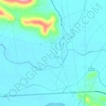
Name: Rena topographic map, elevation, terrain.

Location: Rena, Badajoz, Extremadura, Spain (39.03176 -5.82986 39.06707 -5.77544)

Average elevation: 876 ft

Minimum elevation: 807 ft

Maximum elevation: 1,339 ft

Other topographic maps

Click on a map to view its topography, its elevation and its terrain.

Helechal

Spain > Extremadura

Average elevation: 2,024 ft

Jerte

Spain > Extremadura > Cáceres > Jerte

Average elevation: 2,671 ft

Badajoz

Spain > Extremadura > Badajoz > Badajoz

Average elevation: 692 ft

La Cerecedilla

Spain > Extremadura > La Vera > Garganta la Olla

Average elevation: 2,782 ft

Gear up for your next adventure:

🌎3D Topographic Globes - Raised relief globes for a tactile understanding of geography
🩹Survival Bandages - High‑quality bandages for emergencies
💧Water Purification System - Clean water on the trail with reliable purifiers
🔦Powerful Headlamps - Ultra-bright hands-free lighting for night navigation
🪑Portable Camp Table - Compact table for campsite meals

As an Amazon Associate, this site earns from qualifying purchases at no extra cost to you.