Geolocate

Tazewell topographic map

Click on the map to display elevation.

About this map

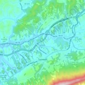
Name: Tazewell topographic map, elevation, terrain.

Location: Tazewell, Tazewell County, Virginia, United States (37.10452 -81.55730 37.15366 -81.47636)

Average elevation: 2,641 ft

Minimum elevation: 2,339 ft

Maximum elevation: 4,173 ft

Tazewell County trails, hiking, mountain biking, running and outdoor activities

Other topographic maps

Click on a map to view its topography, its elevation and its terrain.

Lake Witten

United States > Virginia > Tazewell County

Average elevation: 2,694 ft

Abbs Valley

United States > Virginia > Tazewell County

Average elevation: 2,769 ft

Pounding Mill

United States > Virginia > Tazewell County

Average elevation: 2,444 ft

Glen Burke

United States > Virginia > Tazewell County

Average elevation: 2,638 ft

Tiptop

United States > Virginia > Tazewell County

Average elevation: 2,835 ft

Stony Ridge

United States > Virginia > Tazewell County

Average elevation: 2,648 ft

Indian

United States > Virginia > Tazewell County > Cedar Bluff

Average elevation: 2,234 ft

Mud Fork

United States > Virginia > Tazewell County

Average elevation: 2,881 ft

Gear up for your next adventure:

🧺Microfiber Travel Towels - Compact and fast-drying towels for trail use
❄️Traction Cleats - Prevent slips on icy trails during winter hikes
🧢Outdoor Hiking Hat - Sun protection hat for outdoor explorers
🔌USB Car Charger - Car charger for on‑the‑go power needs
💧Water Filtration Bottles - Safely drink from streams and lakes while exploring

As an Amazon Associate, this site earns from qualifying purchases at no extra cost to you.