Geolocate

Abbs Valley topographic map

Click on the map to display elevation.

About this map

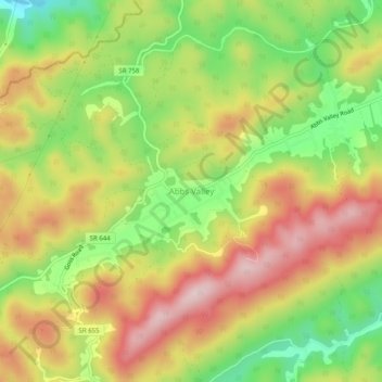
Name: Abbs Valley topographic map, elevation, terrain.

Location: Abbs Valley, Tazewell County, Virginia, United States (37.22400 -81.47233 37.26400 -81.43233)

Average elevation: 2,769 ft

Minimum elevation: 2,221 ft

Maximum elevation: 3,301 ft

Tazewell County trails, hiking, mountain biking, running and outdoor activities

Other topographic maps

Click on a map to view its topography, its elevation and its terrain.

Tazewell

United States > Virginia > Tazewell County

Average elevation: 2,641 ft

Lake Witten

United States > Virginia > Tazewell County

Average elevation: 2,694 ft

Raven

United States > Virginia > Tazewell County

Average elevation: 2,346 ft

Gear up for your next adventure:

🪶Thermal Camp Blanket - Extra warmth for cold nights
🧭Pro Hiking Compasses - High-accuracy liquid-filled compasses for topographic orientation
📷Action Camera - Capture your outdoor adventures in HD
🌎3D Topographic Globes - Raised relief globes for a tactile understanding of geography
🛰️Satellite Messengers - Emergency SOS and two-way messaging for off-grid adventures

As an Amazon Associate, this site earns from qualifying purchases at no extra cost to you.