
Carumas topographic map
Click on the map to display elevation.
About this map
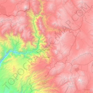
Name: Carumas topographic map, elevation, terrain.
Location: Carumas, Mariscal Nieto, Moquegua, 18400, Perú (-16.95941 -70.90546 -16.46145 -69.99505)
Average elevation: 12,874 ft
Minimum elevation: 4,259 ft
Maximum elevation: 18,957 ft
Other topographic maps
Click on a map to view its topography, its elevation and its terrain.
Calacoa
Calacoa Bellavista es una localidad peruana ubicada en la región Moquegua, provincia de Mariscal Nieto, distrito de San Cristóbal. Es asimismo capital del distrito de San Cristóbal. Se encuentra a una altitud de 3485 m s. n. m. Tenía una población de 1170 habitantes en 1993.
Average elevation: 11,762 ft
Volcán Huaynaputina (Ver Nevado Huaynaputina)
El Huaynaputina (de wayna: ‘joven’, y putina: ‘volcán’, en quechua) es un estratovolcán de la cordillera de los Andes localizado en el departamento de Moquegua, al sur de Perú. Este volcán fue la fuente de la mayor explosión registrada en la historia reciente de América Latina, la cual aconteció…
Average elevation: 14,367 ft