
Shakamak State Park topographic map
Interactive map
Click on the map to display elevation.
About this map
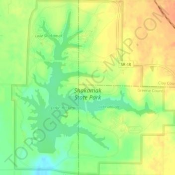
Name: Shakamak State Park topographic map, elevation, terrain.
Location: Shakamak State Park, Greene County, Indiana, United States (39.15653 -87.25541 39.18608 -87.21967)
Average elevation: 574 ft
Minimum elevation: 505 ft
Maximum elevation: 630 ft
Other topographic maps
Click on a map to view its topography, its elevation and its terrain.
Switz City
United States > Indiana > Greene County
Switz City, Greene County, Indiana, 47465, United States
Average elevation: 531 ft
Worthington
United States > Indiana > Greene County
Worthington, Greene County, Indiana, 47471, United States
Average elevation: 531 ft
Linton
United States > Indiana > Greene County
Linton, Greene County, Indiana, 47441, United States
Average elevation: 528 ft
Bloomfield
United States > Indiana > Greene County
Bloomfield, Greene County, Indiana, 47424, United States
Average elevation: 551 ft
White Rose
United States > Indiana > Greene County
White Rose, Greene County, Indiana, United States
Average elevation: 512 ft
Owensburg
United States > Indiana > Greene County > Owensburg
Owensburg, Greene County, Indiana, 47453, United States
Average elevation: 732 ft