Geolocate

White Rose topographic map

Click on the map to display elevation.

About this map

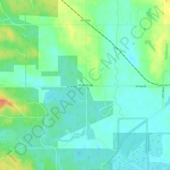
Name: White Rose topographic map, elevation, terrain.

Location: White Rose, Greene County, Indiana, United States (39.01116 -87.24279 39.05116 -87.20279)

Average elevation: 512 ft

Minimum elevation: 469 ft

Maximum elevation: 607 ft

Greene County trails, hiking, mountain biking, running and outdoor activities

Other topographic maps

Click on a map to view its topography, its elevation and its terrain.

Jasonville

United States > Indiana > Greene County

Average elevation: 607 ft

Worthington

United States > Indiana > Greene County

Average elevation: 531 ft

Bloomfield

United States > Indiana > Greene County

Average elevation: 551 ft

Linton

United States > Indiana > Greene County

Average elevation: 528 ft

Switz City

United States > Indiana > Greene County

Average elevation: 531 ft

Lyons

United States > Indiana > Greene County

Average elevation: 512 ft

Gear up for your next adventure:

🧺Microfiber Travel Towels - Compact and fast-drying towels for trail use
🔦LED Headlamp - Bright and durable LED headlamp for night navigation
🗃️Trail First Aid Kit - Essential kit for outdoor injuries and emergencies
🔊Portable Camp Speaker - Music and alerts at camp
🧯Portable Fire Pit - Compact fire pit for camping spots

As an Amazon Associate, this site earns from qualifying purchases at no extra cost to you.