Geolocate

Bloomfield topographic map

Click on the map to display elevation.

About this map

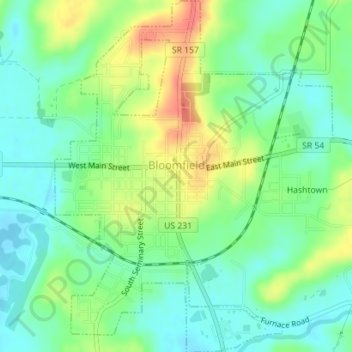
Name: Bloomfield topographic map, elevation, terrain.

Location: Bloomfield, Greene County, Indiana, 47424, United States (39.01242 -86.94969 39.03973 -86.92190)

Average elevation: 551 ft

Minimum elevation: 479 ft

Maximum elevation: 669 ft

Greene County trails, hiking, mountain biking, running and outdoor activities

Other topographic maps

Click on a map to view its topography, its elevation and its terrain.

Newark

United States > Indiana > Greene County

Average elevation: 709 ft

Bushrod

United States > Indiana > Greene County

Average elevation: 495 ft

Owensburg

United States > Indiana > Greene County > Owensburg

Average elevation: 732 ft

White Rose

United States > Indiana > Greene County

Average elevation: 512 ft

Gear up for your next adventure:

🍳Camping Cook Set - Complete cookware for outdoor meals
🏕️Tent Footprint - Protect your tent base from wear
👟Men's Trail Runners - Lightweight footwear for fast-paced exploration and light hiking
🧦Hiking Socks - Comfortable socks to prevent blisters on long hikes
🗺️NatGeo Topo Maps - High-quality waterproof printed topographic maps of US Parks

As an Amazon Associate, this site earns from qualifying purchases at no extra cost to you.