Geolocate

Switz City topographic map

Click on the map to display elevation.

About this map

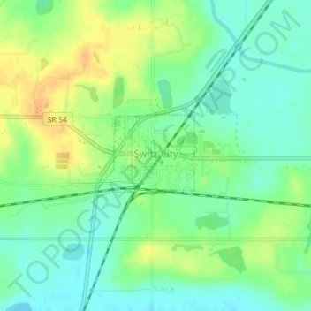
Name: Switz City topographic map, elevation, terrain.

Location: Switz City, Greene County, Indiana, 47465, United States (39.03123 -87.05970 39.03840 -87.04869)

Average elevation: 531 ft

Minimum elevation: 486 ft

Maximum elevation: 591 ft

Greene County trails, hiking, mountain biking, running and outdoor activities

Other topographic maps

Click on a map to view its topography, its elevation and its terrain.

Newark

United States > Indiana > Greene County

Average elevation: 709 ft

Bushrod

United States > Indiana > Greene County

Average elevation: 495 ft

Owensburg

United States > Indiana > Greene County > Owensburg

Average elevation: 732 ft

White Rose

United States > Indiana > Greene County

Average elevation: 512 ft

Gear up for your next adventure:

🪓Survival Multi‑Tool - Versatile tool for camp and trail tasks
🏔️Mountain Trail Maps - High‑detail maps for popular peaks
🕶️GPS Smartphone Mount - Secure mount for phone navigation
🛰️Handheld GPS Units - Professional satellite navigators for precise backcountry mapping
❄️Traction Cleats - Prevent slips on icy trails during winter hikes

As an Amazon Associate, this site earns from qualifying purchases at no extra cost to you.