
南票区 topographic map
Interactive map
Click on the map to display elevation.
About this map
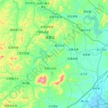
Name: 南票区 topographic map, elevation, terrain.
Location: 南票区, 葫芦岛市, 辽宁省, 中国 (40.85738 120.44899 41.21804 121.03307)
Average elevation: 472 ft
Minimum elevation: -7 ft
Maximum elevation: 2,828 ft
Other topographic maps
Click on a map to view its topography, its elevation and its terrain.