
Make a donation
Gear up for your next adventure:
As an Amazon Associate, this site earns from qualifying purchases at no extra cost to you.
Opodepe topographic map
Click on the map to display elevation.
Make a donation
Gear up for your next adventure:
As an Amazon Associate, this site earns from qualifying purchases at no extra cost to you.
About this map
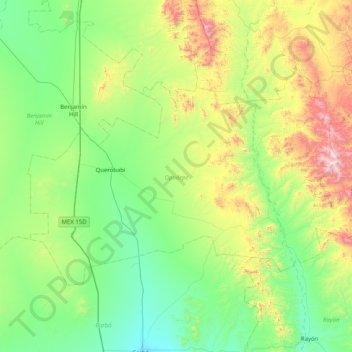
Name: Opodepe topographic map, elevation, terrain.
Location: Opodepe, Sonora, México (29.81858 -111.21792 30.25346 -110.40508)
Average elevation: 2,684 ft
Minimum elevation: 1,522 ft
Maximum elevation: 6,194 ft
Make a donation
Gear up for your next adventure:
As an Amazon Associate, this site earns from qualifying purchases at no extra cost to you.
Other topographic maps
Click on a map to view its topography, its elevation and its terrain.
Ciudad Obregón
La ciudad se localiza en el paralelo 27°29' latitud norte y el meridiano 109°59' longitud oeste. Con una altitud sobre el nivel del mar de 40,8 m en el centro la ciudad.
Average elevation: 194 ft
Hermosillo
México > Sonora > Hermosillo
La localidad de San Pedro o el Saucito (San Pedro el Saucito) está situada en el Municipio de Hermosillo (en el Estado de Sonora). Hay 2,938 habitantes. San Pedro o el Saucito (San Pedro el Saucito) está a 250 metros de altitud.
Average elevation: 814 ft
Heroica Nogales
La ciudad se localiza en el paralelo 31° de latitud norte y el meridiano 110° de longitud oeste de Greenwich, a una altitud de 1200 m sobre el nivel del mar. Se encuentra en el extremo norte del estado a 280 kilómetros de la capital sonorense. La ciudad está conectada con el resto de México por la…
Average elevation: 4,226 ft
Make a donation
Gear up for your next adventure:
As an Amazon Associate, this site earns from qualifying purchases at no extra cost to you.
Agua Prieta
México > Sonora > Agua Prieta
Se encuentra ubicada en el noreste de Sonora, se localiza bajo las coordenadas 31° 19′ 33″ de latitud norte 109° 32′ 57″ de longitud oeste del meridiano de Greenwich a un altitud media de 1213 m s. n. m. (metros sobre el nivel del mar). Su zona urbana tiene un área de 34.76 km². Es cabecera del…
Average elevation: 4,301 ft
Make a donation
Gear up for your next adventure:
As an Amazon Associate, this site earns from qualifying purchases at no extra cost to you.
Make a donation
Gear up for your next adventure:
As an Amazon Associate, this site earns from qualifying purchases at no extra cost to you.
Make a donation
Gear up for your next adventure:
As an Amazon Associate, this site earns from qualifying purchases at no extra cost to you.
Make a donation
Gear up for your next adventure:
As an Amazon Associate, this site earns from qualifying purchases at no extra cost to you.
Make a donation
Gear up for your next adventure:
As an Amazon Associate, this site earns from qualifying purchases at no extra cost to you.
Make a donation
Gear up for your next adventure:
As an Amazon Associate, this site earns from qualifying purchases at no extra cost to you.
Magdalena de Kino
Su topografía se compone de valles y lomas suaves. La región este y noreste es accidentada y la parte sur es plana, casi en su totalidad.
Average elevation: 2,674 ft
Make a donation
Gear up for your next adventure:
As an Amazon Associate, this site earns from qualifying purchases at no extra cost to you.
Make a donation
Gear up for your next adventure:
As an Amazon Associate, this site earns from qualifying purchases at no extra cost to you.
Make a donation
Gear up for your next adventure:
As an Amazon Associate, this site earns from qualifying purchases at no extra cost to you.
Desemboque
El Desemboque se encuentra localiza en las coordenadas geográficas 29°30′18″N 112°23′44″O / 29.50500, -112.39556 y a una altitud de 10 metros sobre el nivel del mar; originalmente su asentamiento era a unos dos kilómetros al norte del actual, sin embargo hacia la década de 1930 fue…
Average elevation: 30 ft
Make a donation
Gear up for your next adventure:
As an Amazon Associate, this site earns from qualifying purchases at no extra cost to you.
Hermosillo
México > Sonora > Hermosillo
La ciudad se localiza en el paralelo 29° de latitud norte y el meridiano 110° de longitud oeste de Greenwich, a una altitud de 210 m sobre el nivel del mar. Se encuentra al centro del estado a 280 kilómetros de la frontera con Estados Unidos. La ciudad es atravesada de sur a norte por la Carretera Federal…
Average elevation: 814 ft
Ciudad Obregón
La ciudad se localiza en el paralelo 27°29′ latitud norte y el meridiano 109°59′ longitud oeste. Con una altitud sobre el nivel del mar de 40,8 m en el centro la ciudad.
Average elevation: 194 ft
Make a donation
Gear up for your next adventure:
As an Amazon Associate, this site earns from qualifying purchases at no extra cost to you.
Hermosillo
México > Sonora > Hermosillo
La ciudad se localiza en el paralelo 29° de latitud norte y el meridiano 110° de longitud oeste de Greenwich, a una altitud de 210 m sobre el nivel del mar. Se encuentra al centro del estado a 280 kilómetros de la frontera con Estados Unidos. La ciudad es atravesada de sur a norte por la Carretera Federal…
Average elevation: 814 ft
Make a donation
Gear up for your next adventure:
As an Amazon Associate, this site earns from qualifying purchases at no extra cost to you.
Heroica Nogales
La ciudad se localiza en el paralelo 31° de latitud norte y el meridiano 110° de longitud oeste de Greenwich, a una altitud de 1200 m sobre el nivel del mar. Se encuentra en el extremo norte del estado a 280 kilómetros de la capital sonorense. La ciudad está conectada con el resto de México por la…
Average elevation: 4,226 ft
Make a donation
Gear up for your next adventure:
As an Amazon Associate, this site earns from qualifying purchases at no extra cost to you.
Magdalena de Kino
La ciudad se localiza en el paralelo 30° de latitud norte y el meridiano 110° de longitud al oeste de Greenwich; a una altitud de 680 metros sobre el nivel del mar. Se encuentra al norte del estado a 87 kilómetros de la frontera con Estados Unidos. La ciudad es atravesada de sur a norte por la Carretera…
Average elevation: 2,674 ft
Hermosillo
México > Sonora > Hermosillo
La ciudad se localiza en el paralelo 29° de latitud norte y el meridiano 110° de longitud oeste de Greenwich, a una altitud de 210 m sobre el nivel del mar. Se encuentra al centro del estado a 280 kilómetros de la frontera con Estados Unidos. La ciudad es atravesada de sur a norte por la Carretera Federal…
Average elevation: 814 ft
Make a donation
Gear up for your next adventure:
As an Amazon Associate, this site earns from qualifying purchases at no extra cost to you.
Make a donation
Gear up for your next adventure:
As an Amazon Associate, this site earns from qualifying purchases at no extra cost to you.
Make a donation
Gear up for your next adventure:
As an Amazon Associate, this site earns from qualifying purchases at no extra cost to you.
Puerto Peñasco
México > Sonora > Puerto Peñasco
La ciudad se localiza en el noroeste del estado de Sonora, en la costa del Golfo de California o Mar de Cortés, sobre las coordenadas geográficas 31°19′36″ de latitud norte y 113°32′52″ de longitud oeste del meridiano de Greenwich, a una elevación máxima de 100 metros sobre el nivel del mar y una…
Average elevation: 30 ft
Make a donation
Gear up for your next adventure:
As an Amazon Associate, this site earns from qualifying purchases at no extra cost to you.
Ciudad Obregón
La ciudad se localiza en el paralelo 27°29′ latitud norte y el meridiano 109°59′ longitud oeste. Con una altitud sobre el nivel del mar de 40,8 m en el centro la ciudad.
Average elevation: 194 ft
Ciudad Obregón
La ciudad se localiza en el paralelo 27°29' latitud norte y el meridiano 109°59' longitud oeste. Con una altitud sobre el nivel del mar de 40,8 m en el centro la ciudad.
Average elevation: 194 ft