
Croteau Lake topographic map
Click on the map to display elevation.
About this map
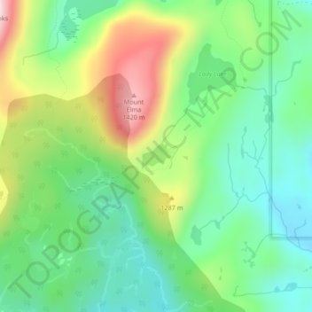
Name: Croteau Lake topographic map, elevation, terrain.
Average elevation: 3,921 ft
Minimum elevation: 3,491 ft
Maximum elevation: 4,718 ft
Other topographic maps
Click on a map to view its topography, its elevation and its terrain.
Dove Creek
Canada > British Columbia > Comox Valley Regional District > Area C (Puntledge/Black Creek)
Average elevation: 138 ft
Forbidden Plateau
Canada > British Columbia > Comox Valley Regional District > Area C (Puntledge/Black Creek)
Average elevation: 3,415 ft
Mount Washington
Canada > British Columbia > Comox Valley Regional District > Area C (Puntledge/Black Creek)
Average elevation: 4,196 ft
Black Creek
Canada > British Columbia > Comox Valley Regional District > Area C (Puntledge/Black Creek)
Average elevation: 194 ft
Mount Becher
Canada > British Columbia > Comox Valley Regional District > Area C (Puntledge/Black Creek)
Average elevation: 3,396 ft
MacAulay Heights
Canada > British Columbia > Comox Valley Regional District > Area C (Puntledge/Black Creek)
Average elevation: 308 ft
Miracle Beach
Canada > British Columbia > Comox Valley Regional District > Area C (Puntledge/Black Creek) > Miracle Beach
Average elevation: 98 ft
Nymph Falls
Canada > British Columbia > Comox Valley Regional District > Area C (Puntledge/Black Creek)
Average elevation: 420 ft
Mount Albert Edward
Canada > British Columbia > Comox Valley Regional District > Area C (Puntledge/Black Creek)
Average elevation: 4,948 ft
Forbidden Plateau
Canada > British Columbia > Comox Valley Regional District > Area C (Puntledge/Black Creek)
Average elevation: 2,133 ft